Hinunangan
| Municipality of Hinunangan | ||
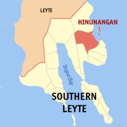
| Location of Hinunangan in the Southern Leyte Province | ||
|---|---|---|

|
||
| Basic data | ||
| Region : | Eastern Visayas | |
| Province : | Southern Leyte | |
| Barangays : | 40 | |
| PSGC : | 086403000 | |
| Income class : | 3rd income bracket | |
| Households : |
May 1, 2000 census
|
|
| Population : | 29,976 August 1, 2015 census
|
|
| Population density : | 175.7 inhabitants per km² | |
| Area : | 170.58 km² | |
| Coordinates : | 10 ° 24 ' N , 125 ° 12' E | |
| Postal code : | 6608 | |
| Mayor : | Gomez, Romeo M. | |
| Geographical location in the Philippines | ||
|
|
||
Hinunangan is a Filipino township in Southern Leyte Province on Leyte Island . It has 29,976 inhabitants (August 1, 2015 census) who live in 40 barangays . The community is described as partially urban . Hinunangan is located approx. 144 km east of the provincial capital Maasin City and can be reached from there via the Maharlika Highway via the municipality of Sogod . The two islands off the coast, San Pedro and San Pablo, belong to the administrative area of the municipality.
There is a Southern Leyte State University campus in the community .
Barangays
|
|
|
