Sogod (Southern Leyte)
| Municipality of Sogod | ||
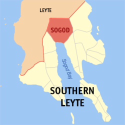
| Location of Sogod in the Southern Leyte Province | ||
|---|---|---|

|
||
| Basic data | ||
| Region : | Eastern Visayas | |
| Province : | Southern Leyte | |
| Barangays : | 45 | |
| PSGC : | 086417000 | |
| Income class : | 2nd income bracket | |
| Households : |
May 1, 2000 census
|
|
| Population : | 44,986 August 1, 2015 census
|
|
| Population density : | 233.5 inhabitants per km² | |
| Area : | 192.70 km² | |
| Coordinates : | 10 ° 23 ' N , 124 ° 59' E | |
| Postal code : | 6606 | |
| Mayor : | Tan, Sheffered Lino S. | |
| Geographical location in the Philippines | ||
|
|
||
Sogod , Cebuano : Lungsod sa Sogod , Tagalog : Bayan ng Sogod , Waray : Bungto han Sogod , is a Filipino municipality in the province of Southern Leyte on the island of Leyte . It has 44,986 inhabitants (August 1, 2015 census) who live in 45 barangays . The community is described as partially urban and is located at the head of Sogod Bay. Sogod is located approx. 71 km northeast of the provincial capital Maasin City and can be reached from there via the Maharlika Highway .
The main campus of Southern Leyte State University is in the community .
Barangays
|
|
|
