
Staghorn cliffs

The Hirschhornklippen (also Hirschhorns ) are a rock formation in the Harz Mountains in Saxony-Anhalt .
The Hirschhorn cliffs as part of the Harz cliffs are located on the Königsberg above the Goetheweg train station a few hundred meters south of the Brocken . The highest point of this group of rocks reaches a height of 1023 m . Politically, the cliffs are located in the municipality of the city of Wernigerode in the Harz district .
The area is located in the core zone of the Harz National Park and is therefore no longer accessible to the public as it is not accessible by paths. The cliffs themselves are designated as a geological natural monument .
history
The cliffs are first mentioned in 1571 on the Hirsch Hornern . In 1587 it is said between the Hartzhernern and the Könnigesbergk , in 1667 under the Hirschhörner , in 1709 the Hirschhorns and in 1725 the Hirschhornerklippe .
Since the beginning of the 18th century, after several mistakes, the border between the county of Wernigerode and the Harzburg office of the Duchy of Braunschweig ran directly between the Hirschhorn cliffs . A border cross carved into the rock and a border marker reminds of this.
Due to their strange appearance, the cliffs were once a popular destination for Brocken hikers.
Individual evidence
- ↑ Federal Agency for Cartography and Geodesy, State Enterprise Geobasis Information and Surveying Saxony (GeoSN): Digital Topographic Map 1:50 000.
- ↑ Natural monuments. Harz district , accessed on November 21, 2010 .
- ^ Ordinance on the establishment of the Hochharz National Park. (PDF; 41 kB) Federal Ministry of Justice, juris GmbH, 1990, accessed on November 21, 2010 .
- ↑ Walther Grosse : History of the city and county of Wernigerode in their forest, field and street names , Wernigerode [1929]

Distant view of the cliffs from the west

Map of the border at the Hirschhornklippen in 1910
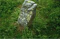
Old border marker on the Hirschhorn cliffs


Coordinates: 51 ° 47 ′ 25 " N , 10 ° 35 ′ 43" E