
Koenigsberg (Brocken)
| Koenigsberg | ||
|---|---|---|
 View from the Brocken to the Königsberg |
||
| height | 1033.5 m above sea level NHN | |
| location | near Schierke ; District of Harz , Saxony-Anhalt ( Germany ) | |
| Mountains | resin | |
| Dominance | 1.1 km → Brocken | |
| Notch height | 39 m | |
| Coordinates | 51 ° 47 '20 " N , 10 ° 35' 58" E | |
|
||


The Königsberg is a side knoll of the Brocken and at 1033.5 m above sea level. NHN the third highest point in the Harz Mountains . It is located near Schierke in the urban area of Wernigerode in the Harz district of Saxony-Anhalt .
geography
location
The Königsberg rises in the core zone of the Harz National Park and in the Harz / Saxony-Anhalt Nature Park . Its summit is 4.8 km northwest of Schierke , a southwestern district of the city of Wernigerode , 1.6 km southwest of the Brocken summit and 1.5 km southwest of Brockenstrasse ( K 1356).
As an elongated ridge, the Königsberg runs from south-east to north-west. The Hirschhörner rock cliffs (max. 1023.2 m ) lie close to the summit on the northwest flank . To the east the landscape slopes down to the Black Schluftwasser , a small tributary of the Kalten Bode flowing south of the mountain . To the east, beyond the Black Schluftwasser, lies the Heinrichshöhe ( 1039.5 m ), another side knoll of the Brocken.
Natural allocation
The Königsberg belongs to the natural spatial main unit group Harz (No. 38) and in the main unit Hochharz (381) to the sub-unit Brocken ( Eastern Brocken massif ; 381.0).
Protected areas
In addition to its central location in the Harz National Park, parts of the Harz landscape protection area and northern Harz foreland ( CDDA no. 20784; designated in 1968; 1587.6238 km² ) and the Hochharz fauna-flora-habitat area (FFH no. 4229 ) are located on the Königsberg -301; 60.23 km²) and the Hochharz bird sanctuary (VSG no. 4229-401; 61.12 km²).
National park and former hiking trails
The mountain in the Harz National Park is closed to hikers. In the past two ways led to the ridge:
- The old Königsbergweg began near the Eckerloch and went up the slope past the old Königsberg quarry to the Kanzelklippen. From there it ran over the Rabenklippe, the old Eckerlochschanze, further towards the Kesselklippe and then through the Goethemoor to the Goetheweg train station. It led over the entire ridge to the Hirschhorn cliffs .
- The old Goetheweg began at the Goetheweg train station and crossed the Königsberg between the Hirschhornklippen and the summit cliff. Then it ran downwards along the Goethemoor to the railway line on Neuer Goetheweg.
Granite cliffs
On the ridge there are several prominent granite cliffs (from east to west):
- Bar cliff,
- Schluftkopf,
- Pulpit cliffs,
- several small unnamed cliffs,
- Raven cliff,
- Kesselklippe,
- Summit cliff of the Königsberg and
- Hirschhornklippen (Hirschhorns).
The Stangenklippe and the pillar-shaped Schluftkopf used to be popular excursion destinations and are located between Brockenstrasse and Brockenbahn . The pulpit cliffs consist of a group of several granite cliffs, some of which are over 20 m high. On the Rabenklippe there is a fireplace about 70 cm in diameter, which was carved into the granite. Your age is unknown. The summit cliff is only about 1.5 m high.
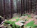
Picture gallery
Old way to the bar cliff
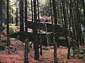
Pole cliff

Old way on the Schluftkopf

Schluftkopf

Small unnamed cliff

Raven cliff from the west

Raven cliff from the north

Fire pit on the Raven Cliff
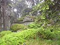
Königsberg, summit cliff
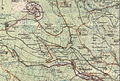
Map of the Königsberg mountain range


Individual evidence
- ↑ a b c Saxony-Anhalt viewer of the State Office for Surveying and Geoinformation ( notes )
- ↑ Map services of the Federal Agency for Nature Conservation ( information )