Eckerloch
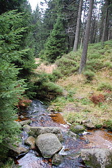
The Eckerloch is a valley basin northwest of the town of Schierke in the Harz in Saxony-Anhalt, which belongs to the city of Wernigerode .
location
The valley basin lies at an altitude of 845 meters, south of the Brocken and is traversed by the Black Schluftwasser . The Eckerlochstieg leads from the Eckerloch north towards the Brocken summit . East toward the station Schierke runs parallel to Brockenbahn the Bahnparallelweg . There is a railway bridge in the Eckerloch for the Brocken Railway. In the Eckerloch there is a refuge and a stamping point for the Harz hiking pin .
history
The name Eckerloch does not go back to the Ecker , which rises significantly further to the west . It is assumed that the name on here may have been initially strengthened occurring Book and thus winning beechnuts points.
In 1923 the Eckerloch was made available for the construction of a ski jumping hill, which was opened in 1927. The wooden Eckerlochschanze was due to its shady location as one of the most snow-sure facilities in Germany. After the ski jump was renewed in 1949, it was named the venue for the GDR championships in ski jumping and as the ski jump of the unit in 1950 . For the championships, the temporarily operated Eckerloch station was set up on the Brockenbahn . Due to its location in the restricted border area , the ski jump could no longer be used after 1961 and fell into disrepair. The ski jump was demolished in the 1970s.
Web links
- Harzer hiking pin: Stamp 11 / Eckerloch , on harzer-wandernadel.de
Individual evidence
- ↑ Eberhard Löblich, On the way to the summit picked up, stories along the Brocken Paths , Mitteldeutscher Verlag Halle (Saale) 2001, ISBN 3-89812-055-4 , p. 13 f.
- ↑ a b Harzer hiking needle: stamp point 11 / Eckerloch , on harzer-wandernadel.de
- ↑ a b Thorsten Schmidt, Jürgen Korsch, The Brocken, Mountain Between Nature and Technology , Schmidt-Buch-Verlag Wernigerode, 5th edition, 2006, ISBN 3-928977-59-8 , p. 46
Coordinates: 51 ° 47 ′ 6 " N , 10 ° 37 ′ 4.1" E


