Holmesburg
Holmes Castle is a neighborhood in the district Near North East (Inner northeast) of the US metropolis of Philadelphia , Pennsylvania . It is located around 15 kilometers northeast of the city center. The place is named after the discoverer of Pennsylvania and confidant of William Penn , Thomas Holme , named and is one of the oldest settlements in Pennsylvania. In the 20th century, the district became known primarily for its prisons . The zip code is 19136.
The district is located on a hill southwest of Pennypack Creek about two kilometers above its confluence with the Delaware . The main streets are Frankford Avenue and Rhawn Street, which intersect at right angles in the former settlement core. The boundaries of the district form the Pennypack in the north, the Delaware in the southeast and Sheffield Avenue in the southwest. The north-east border with Torresdale is rather blurred. The Pennypack or the Academy Road, which is about 1.5 kilometers further away, are possible border lines. The Holmesburg Shopping Center and the prisons, most of which are on the Torresdaler side of the Pennypack, speak in favor of the latter .
Holmesburg sits on what was once designated as the location for the Quaker capital, Philadelphia. After William Penn had received what is now Pennsylvania for his Quaker colonies in 1681, he sent his confidante Thomas Holmes there on an exploration trip. He suggested that hill as the location for Penn's capital, Philadelphia. The location just above the spring tide of the Delaware would have protected the colony from the flood and made it accessible by ship all year round. The core of the settlement would have been on a hill surrounded on three sides by Pennypack Creek. However, Penn preferred to build his city further down the Delaware in its current location. As a thank you for his services, however, Holmes received the region he had selected and founded Holmesburg in that place.
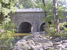
The most important street in town has always been Frankford Avenue. It was part of the New York –Philadelphia– Wilmington route , once the most important trade route on the American east coast, which ran over Pennypack Creek above the floodplain of the Delaware. The importance of this route made it necessary to build a fortified river crossing at the end of the 17th century. Completed in 1697, the Arch Bridge is the oldest stone bridge in the United States. It has been a listed building since 1997 and is still in operation.
The main thoroughfare is Interstate 95 , which runs along the banks of the Delaware. There are two exits in the Holmesburg area, one on Cottman Avenue in the southwest and one on Academy Road in the northeast. The Holmesburg Junction train station is located on the northeast corridor at the junction of the Bustleton Branch , a freight railway of the former Pennsylvania Railroad . The station is served by regional trains on the SEPTA line R7 Trenton - Chestnut Hill East . The travel time to the city center is around 30 minutes. The planned connection to Philadelphia's elevated railway, the Market – Frankford Line , was not realized.
Holmesburg is the location of all of Philadelphia's prisons. The first prison, called Holmesburg Prison, opened on Torresdale Avenue in 1896. It was replaced in 1995 by the Curran-Fromhold Correctional Facility (CFCF) . In the second half of the 20th century, other institutions were added, the Detention Center , the Philadelphia Industrial Correctional Center (PICC) , the Riverside Correctional Facility and the Alternative and Special Detention's Central Unit . These facilities are located southeast of State Road on the Delaware.
Individual evidence
- ↑ Timetable of the R7 line ( Memento of the original from November 27, 2007 in the Internet Archive ) Info: The archive link has been inserted automatically and has not yet been checked. Please check the original and archive link according to the instructions and then remove this notice.
- ^ History of the Philadelphia Prison System on phila.gov
Web links
- Holmesburg.com (English)
Coordinates: 40 ° 3 ′ N , 75 ° 2 ′ W


