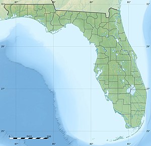
Honeymoon Island (Florida)
| Honeymoon Island | ||
|---|---|---|
| Honeymoon Island State Park | ||
| Waters | Gulf of Mexico | |
| Geographical location | 28 ° 3 '41 " N , 82 ° 49' 36" W | |
|
|
||
| length | 5.2 km | |
| width | 1.2 km | |
| surface | 11.63 km² | |
Honeymoon Island is a golf island in Pinellas County , Florida near Dunedin .
geography
The island off the mainland can be reached by car via the Dunedin Causeway, Florida State Road 586 , which crosses Saint Joseph Sound with the Bascule Bridge . Ferries depart from Honeymoon Island to the neighboring island of Caladesi Island , which cannot be reached by car. Honeymoon Island and Caladesi Island were once an island with the name Hog Island (in German Pig Island) until a hurricane divided the island into two islands in 1921 . The passage between the two islands is called the Hurricane Pass .
Origin of name
The name Honeymoon Island comes from the late 1930s, early 1940s when New York builder Clinton Washburn had bungalows built for couples on their honeymoon .
Honeymoon Island State Park
On Honeymoon Iceland , the Iceland Honeymoon State Park, which is the Florida State Parks counts. The 11 km² nature reserve is characterized by beaches, pine and pine groves and palm forests. The island is popular with those looking for relaxation, shell collectors and ornithologists , as many different species of birds such as pelicans and ospreys can be observed here. Sufficient parking, public shower facilities and picnic pavilions can be found on Honeymoon Island.
Web links
- Honeymoon Island State Park on floridastateparks.org (English)
- Honeymoon Island State Park on Tampabay.com (English)

