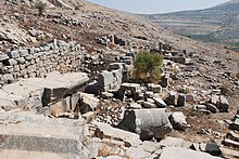
Hosn Niha
Coordinates: 33 ° 54 ' N , 35 ° 57' E
Hosn Niha , also Husn Niha; is a temple complex from Roman times in Lebanon . It is located above Niha in the Lebanon Mountains on the western edge of the Bekaa plain .
location
Hosn Niha is located at an altitude of about 1350 meters on the eastern slope of the Jebel Sannin, which is up to 2682 meters high, the highest point in the south of the Lebanon Mountains, in the district of Zahlé , which belongs to the Bekaa governorate . From Zahlé a side road leads six kilometers to the northeast in the direction of Baalbek , until shortly after the village of Ablah a two-kilometer cul-de-sac branches off to the village of Niha. At the upper end of the village there is an archaeological site with two Roman temples in a wooded stream valley to the left below the road. On the right, a narrow paved road on the north side of the valley leads three kilometers further and a good 300 meters upwards. In the valley floor, grapes are grown just below the temple; the last, unpaved section of the route leads up between steeper mountain slopes, the small soil layer of which is littered with limestone. The temple group is above the path on the slope.
history
Since the middle of the 2nd century, the Romans built many small temples and other shrines as pilgrimage sites on the edge of the Bekaa, most of which were related to the main town of Heliopolis, today's Baalbek. In Roman times a processional street led up from Niha. Above Temnine el-Faouqa a small well sanctuary has been preserved in the northern neighboring valley, in the valley after that there was a large Roman temple in today's village of Qsarnaba .
In the early Byzantine period, a basilica was built on the altar in front of the great temple, partly using stone material from the pagan Romans . The name Hosn Niha is made up of Hosn, Arabic “castle” and Niha, Syriac “the resting, dreamer”. Hosn refers to a modest fortress that is said to have existed here in Islamic times.
Design
The remains of the larger temple A, the basilica B and a smaller temple of the Ante have been preserved. Some distance away, a Roman quarry and the location of the small temple D have been identified.
Temple A was a prostylus temple with four columns with Corinthian capitals on the entrance side . He stood on a triple-stepped podium , which was pulled forward on the long sides to the east in order to form the lateral boundary for an open staircase with 18 steps that led up to the heel of the stylobate . The walls of the cella made of massive limestone blocks were smooth on the outside. The lintel at the entrance portal between the vestibule ( pronaos ) and the cella had a stripe with lesbian kymatia on the lower edge , no relief has been preserved here. At the far end of the cella was the elevated Adyton , on which the figure of the god was worshiped. Below was a crypt that could be entered through a door on the right side of the Adyton front. The building remained partially unfinished, the profiles were only roughly hewn, and the remains of the Ionic capitals found remained unfinished. The square holes that can be seen in the masonry and on the stones lying on the ground are wolf holes . They served as pick-up points for technical aids when transporting and moving the stones. The interior of the temple has been searched by treasure tombs and has not yet been restored. Column fragments are scattered on the floor, the side walls in the eastern area are still partially upright.
In front of the east side of the great temple there was once a large forecourt with an altar. This had to give way to a three-aisled basilica, which was built on almost the entire area of the forecourt. Its entrance was in the west, it had a wider nave and a semicircular apse in the east. The north side apse served as a baptistery . A baptismal font with a diameter of 1.15 meters and part of the mosaic floor were preserved here. From this baptistery, behind the apse, a corridor led past the Diakonikon on the south side of the apse, which was connected to the right aisle.
In 50 meters distance east of the great temple the remains of an Ante temple can be seen, the entrance to the south facing the valley side and the rear facing the slope. The temple did not have a podium. The raised area of the Adyton was missing in the cella; with internal dimensions of 5.6 × 5.7 meters, it was almost square. Only the two lowest stone layers of the lateral vestibule walls ( ante ) have been preserved. An enclosure wall ran around the entire temple area.
literature
- Daniel Krencker , Willy Zschietzschmann (Ed.): Roman temples in Syria. After recordings and investigations by members of the German Baalbek expedition 1901–1904 and own recordings in 1933 (= Monuments of ancient architecture. 5, text volume, ZDB -ID 535277-0 ). Text tape. de Gruyter, Berlin et al. 1938, pp. 122-134.
Web links
- Upper temples. Hosn Niha. American University of Beirut Photo Temple A from the east
Individual evidence
- ^ Itinerary 12-E Niha. Lebanon Ministry of Tourism, Discover Lebanon Guide ( page no longer available , search in web archives ) Info: The link was automatically marked as defective. Please check the link according to the instructions and then remove this notice.


