
Hovenweep National Monument
| Hovenweep National Monument | |||
|---|---|---|---|
 |
|||
|
|||
| Location: | Utah , United States | ||
| Next city: | Cortez | ||
| Surface: | 3.2 km² | ||
| Founding: | March 2, 1923 | ||
| Visitors: | 26,662 (2005) | ||
 |
|||
 |
|||
 |
|||
_location_map.svg)
The Hovenweep National Monument is located on the border between the states of Colorado and Utah west of the town of Cortez . It was established on March 2, 1923 by President Warren G. Harding . The National Monument consists of six non-contiguous areas of Native American ruins . Holly Canyon , Hackberry Canyon , Cutthroat castle and Goodman Point are in Colorado, while Cajon and Square Tower are in Utah. The administration is located near the Square Tower .
history
In 1854, a Mormon expedition led by WD Huntington discovered the ruins, which the Indians, the Ute and Navajos , had long known to be living there. The expression Hovenweep comes from the Ute language and means something like barren valley. The term was adopted by painter and photographer William Henry Jackson in 1874 .
archeology
The residents of Hovenweep lived from about the year 900 onwards from farming. In the very dry landscape for most of the year, the success of the cultivation depended on the rainfall in winter and spring and the occasional thunderstorm in summer. In order to secure the growth of plants, as in the entire area of the Pueblo culture, small dams were drawn across the irregular watercourses, from which the water was diverted to the arable land. A 23-year dry spell that began after the tree ring dates in 1276 made the cultivation impossible and forced the residents of Hovenweep to leave their homes. The architecture is characterized by square, round or semicircular towers and buildings that are usually two to three storeys high; the function is not clear. The actual pueblos with their residential buildings were neighboring, they can only be recognized as heaps of stones.
Main group (Square Tower)
This group, which is located close to the visitor center, contains the largest number of buildings, including around 30 kivas . It is named after the square tower near a small spring. This group includes other structures on the edge or slope of the canyon: Hovenweep Castle, Hovenweep House, Rim Rock House, Twin Towers, Stronghold House and Unit-type house.
Cutthroat Castle Pueblo
This group of structures is a bit down from the beginning of a canyon. The assembly includes a large number of Kivas, whereby the one in Cutthroat Castle was not built half underground, as usual, but on a boulder. Even if not many buildings can be seen on the surface, the pueblo was relatively large. The Cutthroat Castle consists of the mentioned kiva, which, however, is also surrounded by a peculiar solution, which can be reached from below the rock through a crevice.
Holly
The group of buildings, named after a rancher and trader in the 19th century, consists of two complexes, the Tilted Tower and the Boulder House. The first complex consists of a tower with originally several floors, which later fell into the canyon on the edge of which the building stands. The Boulder House was also a tower-like structure with several floors. It lies on a boulder right next to a seepage spring and was built around 1200, whereby the individual floors were bricked up one after the other from the inside. Access to the entrance was through the rock surface, on which easy steps can be seen.
Horseshoe
A tower with rounded walls was built here, which allows a wide view of the canyon at the top of which it stands. The group also includes the Horseshoe House, which consists of four buildings that together form the shape of a horseshoe.
Hackberry
The Hackberry Group is approximately 500 meters east of the latter group. It is a large group of structures, only one of which is well preserved.
Cajon
This pueblo is about 14 km southwest of the Hovenweep visitor center. It consists of several structures, situated at the top of a canyon as usual, some under a protruding rock. Rocks were also used to stabilize the free-standing buildings. This is best seen in the round tower. The remains of an earth dam have been preserved in the canyon, showing the importance of the water and its storage in ancient times for the inhabitants.
- Hovenweep groups
 Twintowers
 Hovenweep Castle
 Cutthroat group
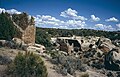 Holly group


See also
- National Monuments in the United States
- Canyons of the Ancients National Monument
- Mesa Verde National Park
Web links
- National Park Service: Hovenweep National Monument (official site; English)
Individual evidence
- ↑ The information on culture is based on: National Park Service: Hovenweep National Monument - History and Culture , unless otherwise stated