Huma (Odisha)
| Huma | ||
|---|---|---|
|
|
||
| State : |
|
|
| State : | Odisha | |
| District : | Sambalpur | |
| Location : | 21 ° 18 ′ N , 83 ° 56 ′ E | |
| Height : | 145 m | |
| Area : | 2.54 km² | |
| Residents : | 619 (2011) | |
| Population density : | 244 inhabitants / km² | |
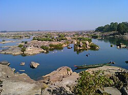
| Huma - Mahanadi | ||
Huma is a village with about 600 inhabitants in the Indian state of Odisha . The temple of the village has one of the very few sloping Shikhara towers in India.
location
Huma is located on the Mahanadi River about 22 km south of Sambalpur at an altitude of about 145 m above sea level. d. M. The climate is warm; Rain falls almost exclusively in the monsoon months from June to September.
population
The predominantly Odiya- speaking inhabitants of the place are predominantly Hindus ; other religions hardly play a role among the rural population of India. The male and female proportion of the population are approximately the same.
economy
Agriculture plays the main role in the villages of India; sometimes chickens and / or dairy cows are also kept. In the village there are small traders, craftsmen and day laborers. Because of a river island, Huma was very suitable as a ford through the Mahanadi River.
history
Nothing is known about the history of the village. The temple possibly dates back to the Middle Ages; However, inscriptions show later changes and extensions in the 17th and 18th centuries.
Attractions
Only attraction of Huma is close to the river Mahanadi standing and the Hindu -God Shiva consecrated Bimaleswara Temple . Its leaning Shikhara tower was probably created by undercutting during the floods that regularly occur in the monsoon season. Almost the entire temple is whitewashed with white paint; figurative jewelry is missing.
Web links
- Huma, Shiva Temple (Wikipedia, English)


