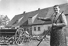
Hundisburger Str. 43
The building at Hundisburger Straße 43 is a new farmer's house in the Althaldensleben district of the city of Haldensleben in Saxony-Anhalt . The residential stable was built in the 1950s in connection with the land reform in the Soviet occupation zone and is now used as a residential building.
location
The former farmhouse is just before the end of the village on the east side of the arterial road from Althaldensleben to Hundisburg . It stands at right angles to the direction of travel, the west gable is oriented towards the nearby Althaldensleben-Hundisburg landscape park .
history
In the course of the land reform in 1945, the owners of the former monastery in Althaldensleben (the industrial family Hugo Henkel ) were expropriated. The farm's agricultural land was divided among new farmers, and a machine yard was set up. From 1948 new farmhouses were built that combined apartment, stable and barn under one roof.
architecture
The elongated stable house on a rectangular floor plan has a suspended part of the barn with a traditional functional structure. It is a type construction from 1949 (model "Altmark"). A large garden area belongs to the property.
Monument protection
In the local register of monuments , the building is registered as a monument under registration number 094 84413 . For Althaldensleben, the building complex is regarded as a socially and historically remarkable monument to the history of the new farmers after the land reform.
See also
Web links
Individual evidence
- ^ From the Empire to the Present, MTS building , website of the Ecomusées Haldensleben-Hundisburg
- ↑ List of monuments of the State Office for Monument Preservation and Archeology Saxony-Anhalt , May 22, 2017, page 682, Haldensleben-Althaldensleben, registration number: 094 84411, date of registration: August 6, 1998
Coordinates: 52 ° 15 '30.4 " N , 11 ° 25' 5.5" E

