Hurricane Erika (1997)
| Category 3 hurricane ( SSHWS ) | ||
|---|---|---|
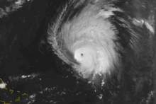
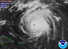
| Hurricane on September 8, 1997 north of the Lesser Antilles | ||
| Emergence | September 3, 1997 | |
| resolution | September 20, 1997 | |
|
Peak wind speed |
|
|
| Lowest air pressure | 946 mbar ( hPa ; 28 inHg ) | |
| dead | 2 direct | |
| Property damage | US $ 10 million (1997) | |
|
Affected areas |
Lesser Antilles , Azores , Puerto Rico | |
| Season overview: 1997 Atlantic hurricane season |
||
The Hurricane Erika was the strongest and longest-lasting tropical cyclone of the Atlantic hurricane 1997 season . Erika evolved from a tropical wave on September 3rd and was moving in a northwesterly direction across the tropical Atlantic Ocean. The wave intensified steadily until it was finally awarded hurricane status on September 4th . This made Erika the fifth named storm, the third hurricane, and the only major hurricane of the season. Erika bridged the short distance to the north of the Lesser Antilles and later turned north due to an approaching low pressure area . The hurricane grew stronger quickly, peaking on September 8 with winds up to 205 km / h (125 mph). After Erika sustained this high for 24 hours, the hurricane began to weaken as it moved over colder water. It turned east, regressed into a tropical storm, and became an extratropical cyclone after passing the Azores .
The hurricane generated light rains and winds over the entire northern part of the Lesser Antilles. Erika carried a cloud of volcanic ash from an eruption on the Soufrière Hills ( Montserrat ) volcano to Antigua , which is a very rare occurrence. Heavy waves from the hurricane created coastal erosion and northern Puerto Rico's coastal flooding that killed two surfers. Moderate wind gusts meant that thousands of residents had to do without electricity. The damage in the Caribbean areas of the USA amounted to 10 million dollars (1997 USD, 12.6 million USD in 2006). In addition, Erika generated stormy winds and light rains in the Azores. Erika was the only tropical rainstorm in the Atlantic Ocean between August and September . The last time this happened was in the 1929 Atlantic hurricane season.
Storm story
A large tropical wave that eventually became Erika departed the coast of Africa on August 31st. Shortly after leaving the coast there was a planetary circulation, but since the wave moved westward, the circulation could not significantly weaken it. On September 3rd, when the tropical wave was about 1,850 kilometers from the southernmost tip of the Lesser Antilles, the convection in the circulation had organized itself enough to classify the system as a tropical cyclone (level 6). The cyclone was traveling northwest at approximately 20 mph (32 km / h) and late on September 3 the system strengthened into a tropical storm. From now on, the National Hurricane Center in Miami named the storm "Erika".
Erika moved further northwest and by early September 4th an eye feature appeared to have developed in the center of the convection, i.e. a calm zone in the center of the storm.
The feature was not an eye, but, as existing satellite imagery revealed, a center briefly exposed from convection. Despite unfavorable wind shear, Erika continued to strengthen and became a hurricane on September 4th, 850 km southeast of Guadeloupe. Deep convection developed again near the center and it slowly got stronger as it moved northwest.

Erika slowed down as he approached the Lesser Antilles. An approaching low pressure area weakened the subtropical high pressure spur and caused Erika to turn north and later north-east. On September 7th, Erika began to get stronger faster. The hurricane peaked 565 km north of the Lesser Antilles on September 8, at 205 km / h (125 mph). 24 hours later, Erika weakened again over cool water. After traveling more than 565 km eastwards, Erika turned northeast in response to westerly currents. Strong wind shear weakened the hurricane back to a tropical storm on September 12th. Even if it kept the deep convection in the center despite the unfavorable atmospheric conditions, Erika weakened further with the swivel to the southeast. On September 14th, the storm became stronger again with a turn to the northeast, 820 km southwest of the Azores, but when passing the Azores Islands the storm quickly weakened due to the disappearance of the deep convection. Erika became an extratropical cyclone in the north of the Azores on September 16th and after executing a right-hand spiral, the extratropical cyclone disappeared about 370 km from Ireland on September 19th.
Preparations
Early on in the cyclone's path, computers struggled to predict the future of Tropical Storm Erika. Some calculated a route through the Lesser Antilles, while others predicted a northward movement. As a result, the Saint Martin government did not issue a tropical storm warning until September 4th. Over the next few days, the governments of Antigua, Montserrat, Barbuda, St. Kitts and Nevis, Anguilla, Dominica, Guadeloupe and Saint Barthelemy also issued a warning. When Erika's movement suggested a path near the islands, all of the above governments except Guadeloupe increased the storm warning to a hurricane warning. Early predictions saw the Bermuda Islands under threat.
The governments of the islands in Erika's predicted path recommended radio instructions to local people to prepare quickly for the hurricane. Many residents in the Lesser Antilles had prepared for the new hurricane season months before the arrival of Hurricane Erika. In Puerto Rico, fishermen protect their boats in preparation for the hurricane. In addition, many residents on this island bought an emergency power supply.
Officials in Anguilla enacted a plan to cut power to the island if the wind exceeded 80 km / h (50 mph). The Guadeloupe government recommended that all residents not leave their homes. Officials closed the Pointe-a-Pitre airport in Guadeloupe. As a precautionary measure, the Saint Martin authorities issued a ban on all service workers. A cruise ship changed course to avoid the island of Saint Thomas.
Damage
Erika caused strong waves across the Lesser Antilles. The highest occurred at 3–3.7 meters in Saint Martin. Here the waves flooded roads and damaged a building under construction near the coast. The outer squalls of Erika passed the island and left a total of precipitation of up to 48.6 mm per square meter.
Anguilla reported winds of up to 55 km / h and some rain. Because of the eruption of the Soufriére Hills volcano in Montserrat, weeks before the formation of Erika, Erika caused an ash cloud over Antigua. Although the ash clouds were receding from the island, authorities considered closing a school because of ash rain.
At the Cyril E. King Airport in Saint Thomas, the storm reached speeds of around 60 km / h with gusts of up to 76 km / h. The external gusts of wind caused light to moderate rain in the Virgin Islands. Erika collided with 31 ships from September 4th to 18th.
Because of the minimal damage the hurricane caused, the name "Erika" has not been removed from the list of names for tropical storms. It was reused in 2003 and is on the list for the names of the Atlantic Hurricane Season in 2009.
credentials
- ↑ Lawrence: September Monthly Tropical Weather Summary (TXT) National Hurricane Center. 1997. Archived from the original on October 25, 2012. Info: The archive link was automatically inserted and has not yet been checked. Please check the original and archive link according to the instructions and then remove this notice. Retrieved November 12, 2006.
- ^ Miles B. Lawrence: Hurricane Erika Tropical Cyclone Report . National Hurricane Center. 1997. Retrieved November 10, 2006.

