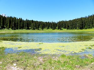
Igelsee (Gaistal)
| Igelsee | ||
|---|---|---|

|
||
| Igelsee seen from the east | ||
| Geographical location | Gaistal , Tyrol | |
| Tributaries | inflow | |
| Drain | drainless | |
| Location close to the shore | Ehrwald | |
| Data | ||
| Coordinates | 47 ° 22 '34 " N , 10 ° 58' 24" E | |
|
|
||
| Altitude above sea level | 1534 m above sea level A. | |
| surface | 2.9 ha | |
| length | 250 m | |
| width | 180 m | |
|
particularities |
periodic lake |
|
The Igelsee (also Egelsee , Negelsee ) is a lake in Tyrol .
It is located in a hollow below the Igelskopf ( 2224 m above sea level ) in the upper Gaistal between the Wetterstein Mountains in the north and the Mieminger Mountains in the south in the municipality of Ehrwald . The superficial outflow-free lake belongs to the catchment area of the Leutascher Ache, known on the upper reaches of the Gaistalbach and flowing eastwards .
The lake is a periodic body of water with a fluctuating water level and the associated variable lake area. After periods of low precipitation and high evaporation , it can dry out completely.
The immediate vicinity of the Igelsee is used as pasture in summer, which is why the grassy bank is usually heavily trodden by cattle. The Igelsee is located on the forest road between Ehrwald and Leutasch and can be easily reached on foot or by bike.

