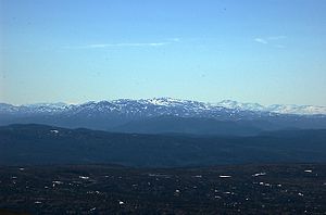
Ilfjellet
| Ilfjellet | ||
|---|---|---|
|
Ilfjellet as seen from Kråkfjellet. |
||
| height | 1218 moh. | |
| location | Trøndelag Province , Norway | |
| Dominance | 21.3 km → Digerhøa | |
| Notch height | 788 m | |
| Coordinates | 62 ° 56 '44 " N , 9 ° 56' 29" E | |
| Topo map | 1520 I. | |
|
|
||
The Ilfjellet is a 1218 moh. high mountain in Norway . It is located in Trøndelag Province and belongs to the Rennebu municipality . It is located in the northeastern part of the municipality, about 13.2 km north of the village of Berkåk and 11.1 km southeast of Å in the municipality of Meldal . The notch height of the mountain is 788 to 790 m, the dominance over the next higher mountain, the Digerhøa (1254 moh.), Is about 21.3 km.
Web links
Individual evidence
- ↑ Store Norske Leksikon - Ilfjellet , snl.no, accessed on December 28, 2012 (Norwegian)
- ↑ Google Maps rangefinder Ilfjellet - Berkåk - Å , maps.google.de, accessed on December 28, 2012
- ↑ Ilfjellet - 1,218m , peakbook.org, accessed December 28, 2012
- ↑ Toppomania - Ilfjellet 1218 moh - fakta ( Memento of the original from January 31, 2012 in the Internet Archive ) Info: The archive link was inserted automatically and has not yet been checked. Please check the original and archive link according to the instructions and then remove this notice. , toppomania.info, accessed December 28, 2012 (Norwegian)
- ↑ Map of the surroundings of Ilfjellet ( page no longer available , search in web archives ) Info: The link was automatically marked as defective. Please check the link according to the instructions and then remove this notice. , ut.no, accessed on December 28, 2012 (Norwegian) in connection with Google Maps rangefinder Ilfjellet - Digerhøa , maps.google.de, accessed on December 28, 2012

