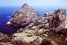
Illas Cíes

The Illas Cíes (name in Galician language , Spanish Islas Cíes ) are a small group of islands , located off the Morrazo Peninsula on the coast of Galicia near the city of Vigo in northwestern Spain . The archipelago consists of three uninhabited islands : Monteagudo (North Island), Do Faro (Central Island) and San Martiño (South Island).
The north island of Monteagudo is separated from the coast of Cabo Home on the Morrazo Peninsula by the northern channel, the south island of San Martiño from the coast of Cabo Santoulo by a strait known as Freu da Porta . In the meantime, the central island of Do Faro has connected to Monteagudo through a tombolo (sand deposit). This forms the 1,200 meter long Playa de Rodas .
In 1980 the Islas Cíes were declared a nature reserve. The archipelago has been part of the Islas Atlánticas de Galicia National Park since 2002 . The islands have a total land area of 455 hectares .
In February 2007 the British daily The Guardian declared Playa de Rodas the most beautiful beach in the world.
Web links
Individual evidence
- ↑ Xunta de Galicia: Illas Cíes , accessed November 26, 2012.
- ↑ guardian.co.uk: Top 10 beaches of the world , February 16, 2007, accessed September 20, 2008.
Coordinates: 42 ° 14 ′ N , 8 ° 54 ′ W
