
Imai-cho


Imai-chō ( Japanese 今井 町 ), today a district of Kashihara in Nara prefecture, was an independent temple and later trading town in the Edo period (1603–1868), which survived the time undamaged and which today is one with its historical architecture Tourist attraction is.
history
The place name Imai appears for the first time in 1386 in a document from the Ichijō-in of the Kōfuku temple in Nara. The actual development took place in the politically troubled Tembun years (1532–1555). As an offshoot of the Jōdo Shinshū branch of Buddhism, the Shōnen Temple ( 称 念 寺 ) was built there, around which well-fortified monks settled. The place was laid out according to plan with streets that ran in north-south and east-west directions, and surrounded by a wall and moat. When Oda Nobunaga invaded Kyōto in 1568 and drove out the Shōgun Ashikaga Yoshiaki and took the Hongan-ji in Osaka, Imai offered resistance, but had to submit in 1575, mediated by Akechi Mitsuhide . In exchange with Osaka and Sakai , the city managed to develop into a prosperous trading city and largely to maintain its independence.
In the course of the Meiji restoration from 1868, the city with the district ( -gun ) Takaichi of the province of Yamato after the first reorganization of the prefectures in 1871 part of the prefecture (-ken) Nara , from 1876 Sakai . From 1881 it belonged to the prefecture (-fu) Osaka , from 1887 back to Nara. When modernized municipal regulations were introduced in 1889, Imai became a district town (- chō ) and expanded to the previous village of Shōkō ( 小 綱 村 , - mura ) in the north. In 1956 it merged with five other communities from Takaichi County to form the independent city ( -shi ) Kashihara and became a district (-chō) of this.
City layout
The city, fortified with ramparts and moats, with the Shōen Temple as its center, had an east-west extension of 610 m and a north-south extension of 310 m at the beginning of the Edo period. The number of households was 1,200, the population a good 4,000. There were six districts: North City (N; 北 町 Kitamachi ), East City (O; 東 町 Higashimachi ), South City (S; 南 町 Minamimachi ), West City (W; 西 町 Nishimachi ), New Town (Ne; 新 町 Shinmachi ) and Ima (I; 今 町 Imamachi ). There were nine gates in the ramparts that were accessed via stone bridges. The course of the streets in the interior was not always straight, but had kinks that made orientation difficult for an invading enemy. A number of old town houses have been preserved, a number of which can be visited.

Legend: Buddhist temples ( -ji ) and Shintō shrines ( -jinja ): (A) Hachiman -jinja (B) Junmyō-ji (C) Remmyo-ji (D) Saikō-ji (E) Kasuga-jinja (F) Shōen-ji. Buildings distinguished as an important cultural asset of Japan : (1) Imanishi House, 1650 (2) Toyoda House, 1662 (3) Nakahashi House, 2nd half of the 18th century (4) Ueda House, mid-18th century (5) Otomura house, 2nd half of 17th century (6) Kyū Kometani house (mid 18th century), (7) Kawai house, end of 18th century (8) Takagi house, beginning 19th century (9) Kyū Ueda House, 1805.
Imai today
The original city layout has largely been preserved to this day. Wall and moat have partially disappeared, however, and a few road openings within the city and across the moat make traffic easier. For a long time, the well-preserved cityscape was disturbed by the power poles and wires. The lines have now been laid underground.
Example: Kawai House

Imai traders mostly came from the surrounding villages. This family in this house named their business Jōhonji-ya ( 上品 寺 屋 ) after their place of origin, Jōhonji-mura. In the 18th century the sake brewery started there, which in Temmei 5 (1785) processed 280 Koku rice. Mainly the south of the province of Yamato was supplied . With the beginning of the Meiji period, sake sales declined. As is usual with the other sake breweries, a sticks ball ( 杉 玉 , Sugitama ) on the house was used to draw attention to the business.
The house on a street corner was rebuilt in the middle of the 19th century. When Emperor Meiji paid a visit to Imai in 1877, the south side was taken back somewhat in the course of a road widening. The house with an almost square floor plan is laid out on two floors. On the first floor there were more rooms behind the sales rooms. The brewery building was behind it.
photos

Kawai house

Sugitama
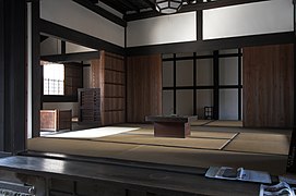
In the Kometani house

In the Kometani house
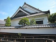
Imanishi house
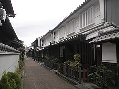
Street scene


literature
- Gert Kaster: Imai-chō - a small town as a preservation district. In: Siegfried RCT Enders and Niels Gutschow (eds.): Hozon. Architectural and urban conservation in Japan. Edition Axel Menges, Stuttgart 1998, p. 188
- Leaflet on Imai-chō
- Leaflet on the Kawai House
Remarks
- ↑ In the case of the Kawai House, there are several balls today.
Web links
- Udo Baumann, Siegfried Enders and Heinz Wionski: Summary: Monument ensembles - review of a first trip to Japan. State Office for Monument Preservation Hesse , [1997]
- Mediation for Urban Conservation: The Case of Imai-cho, Japan. Global Development Research Center, Kobe, Japan (English)
- Imai (Japanese)
Coordinates: 34 ° 30 ′ 26 " N , 135 ° 47 ′ 11" E