Indian Well State Park
The Indian Well State Park is a State Park in Fairfield County in Connecticut , USA.
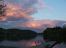
The park is 62 acres and is in the Shelton City area . The park consists of woodland, meadows and fields. The park is on the west bank of the Housatonic River . The main attraction of the park is Lake Housatonic, a reservoir with a small beach and boat moorings .
The park is a popular recreational area with opportunities for hiking , picnicking , swimming , fishing , rowing and renting motor boats .
Indian Well State Park was established in 1928. The name comes from an Indian Romeo and Juliet legend that is said to have taken place at the spring and waterfall.
Web links
Individual evidence
- ↑ Connecticut Walk Book, West ( Memento of the original from May 2, 2008 in the Internet Archive ) Info: The archive link was automatically inserted and has not yet been checked. Please check the original and archive link according to the instructions and then remove this notice. , 19th Edition, Connecticut Forest & Park Association, 2006, Meriden, CT
- ↑ CT Angler's Guide, 2007 ( Memento of the original dated February 2, 2013 in the Internet Archive ) Info: The archive link was inserted automatically and has not yet been checked. Please check the original and archive link according to the instructions and then remove this notice. , p.20, CT DEP
- ^ New Haven Rowing Club: Regattas . Archived from the original on August 16, 2010. Info: The archive link was automatically inserted and not yet checked. Please check the original and archive link according to the instructions and then remove this notice. Retrieved January 21, 2010.
- ^ DEP Boat Launch Information - Lake Housatonic, Indian Well
- ^ Indian Well State Park . In: State Parks and Forests . Connecticut Department of Energy and Environmental Protection. Retrieved April 20, 2014.
Coordinates: 41 ° 20 ′ 13 ″ N , 73 ° 7 ′ 19 ″ W.
