Isla Campana
| Isla Campana | |
|---|---|
| Waters | Pacific Ocean |
| Geographical location | 48 ° 20 ′ S , 75 ° 15 ′ W |
| length | 77.6 km |
| width | 27.9 km |
| surface | 1187.8 km² |
| Highest elevation | 1311 m |
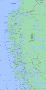
The Isla Campana is an island in the south of Chile . It lies in the Pacific Ocean and is the eleventh largest island in the country with an area of 1188 km².
The island is located between the Gulf of Penas and the Castillo Canal in the Aysén region , the Capitán Prat province and the Tortel commune . It is the largest island in the Campana archipelago of the same name .
geography
Campana is elongated in shape, 78 km long and 28 km wide, and oriented in the NNW-SSE direction. There are many mountain lakes and offshore islands. The coast is 589 km long and consists of cliffs and is characterized by many peninsulas, canals and bays. The canals are generally clean and easy to navigate, but some are also filled with golf rods . The island is very mountainous. There are highlands and gorges; the highest peak reaches 1311 meters. On the northwest coast are the peaks Dora Norte and Dora Sur, the latter is 698 meters high. Other important elevations are the Serrucho mountain at 785 meters, the Roth mountain, the Agudo peak and the Tiburón hill.
Bergrent is the island to the north by the Pacific Ocean, to the west by the Pacific Ocean and the Octubre Canal, which separates Campana from the islands of Lynch, Cabrales and Riquelme, to the south by the Canal des Castillo, which borders it from Aldea, and to the east through the Fallos Canal, which borders the Wellinton Archipelago with Isla Wellington .
Puerto Barbara is on the north coast. The port is anchored 6–8 meters deep and is only suitable for small ships that have a local pilot with them.
history
Since the discovery of the Strait of Magellan in 1520, the Patagonian channels have been extensively explored. In old letters, the Patagonia region between the 48th and 50th parallel south was occupied almost exclusively by a large island called "Campana", which came from the mainland through the canal of the nation "Calén", which ran until the eighteenth century between the 48th and 18th centuries 49. Southern parallels supposed to have existed, was separated. Since the middle of the 20th century, this and other canals have been safely navigable thanks to numerous hydrographic works carried out on the dangerous coasts.
For over 6000 years, the region has been inhabited by the Kaweskar , Chilean indigenous people who live as canoe nomads. At the beginning of the 21st century, they were almost extinct due to the white settlers and the diseases they brought in.
Geology and climate
The entire Patagonian archipelago dates back to the Tertiary and was formed with the Cordillera de la Costa and the Andes . In the last ice age it took its present form as a southern continuation of the coastal mountains. Campana is of volcanic origin, as can be recognized by the type of rock and by its rough and irregular relief, which is characteristic of chains of eruptions.
The region is constantly affected by westerly winds and the passage of frontal systems. These frontal systems are created at 60 degrees south latitude, where subtropical and polar air masses converge, creating a low pressure belt that forms the frontal systems. The climate is known as cold-temperate rainy and extends from the southern part of the Lagos region to the Strait of Magellan . The atmospheric clouds are high, clear days are scarce. The average temperature is 9 ° C. Rainfall is common throughout the year, but autumn is the rainiest.
literature
- Instituto Geográfico Militar (1970). Atlas of the Republic of Chile Santiago - Chile - Military Geography Institute. Second edition.
- Instituto Hidrográfico de la Armada de Chile (1974). Hydrographic Atlas of Chile. Valparaíso - Chile - Hydrographic Institute of the Navy. First edition.
Web links
- Revista Mar Liga Marítima de Chile , ligamar.cl
- UCV geological oceanography , biblioteca.cl (archived)
- Topographic map of the island
