
Isla Mujeres
| Isla Mujeres | ||
|---|---|---|
 |
||
| Waters | Yucatán Street | |
| Geographical location | 21 ° 14 '14 " N , 86 ° 44' 7" W | |
|
||
| length | 7 km | |
| width | 650 m | |
| surface | 4.218 km² | |
| Residents | 12,642 (2010) 2997 inhabitants / km² |
|
| main place | Isla Mujeres | |

The Isla Mujeres [ 'isla mʊ'xeɾɛs ] (' Island of Women ') is an island on the Mexican Caribbean coast in the state of Quintana Roo . Isla Mujeres is located about 13 km north of the resort of Cancún . It has a population of 12,642 (2010). The main source of income is tourism . The island is approximately 7 km long and 650 meters wide, with an area of 4.2 km². The west coast has been part of the Costa Occidental de Isla Mujeres, Punta Cancún y Punta Nizuc National Park since 1996 .
Since the incorporation of several other localities in 2011, Isla Mujeres has also been the only locality on the island, as well as the administrative seat and largest town of the Municipio Isla Mujeres . Since 2015 the place has been recognized as Pueblo Mágico .
history
The island has been around since 550 BC. Used by the Maya . At that time, however, the island was not permanently inhabited, but a sanctuary was located on it in honor of the Mayan goddess Ixchel .
The Spanish conquistador Francisco Hernández de Córdoba discovered the island in March 1517.
During the War of the Castes in 1850, the island was conquered by rebel Maya.
Infrastructure
The island is connected to the mainland by fast ferries that leave from Puerto Juárez .
art
Jason deCaires Taylor has installed several underwater sculptures off the coast of the island. As artificial reefs, these should develop into an attraction for divers.
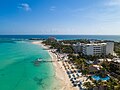
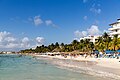
Picture gallery
The beach "Playa Norte" on Isla Mujeres

Aerial view of Isla Mujeres in Mexico

Punta Sur Park at the southernmost point of Isla Mujeres

Isla Mujeres
The island of Mujeres is known for its beaches
.jpg)
.jpg)
.jpg)
.jpg)
.jpg)
Town twinning
- Mar del Plata , Argentina