Isle of May
| Isle of May | ||
|---|---|---|
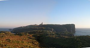
| The Isle of May as seen from the North Cape | ||
| Waters | Firth of Forth ( North Sea ) | |
| Archipelago | Islands of the Forth | |
| Geographical location | 56 ° 11 '9 " N , 2 ° 33' 27" W | |
|
|
||
| length | 1.8 km | |
| width | 500 m | |
| surface | 45 ha | |
| Highest elevation | Kettle Hill 50 m |
|
| Residents | uninhabited | |
| Lighthouse on the Isle of May | ||
The Isle of May ( Scottish Gaelic Eilean Mhàigh ) is a Scottish island and is located in the northern Firth of Forth about 8.0 kilometers off the coast of Fife near Anstruther . It is 1.8 kilometers long and half a kilometer wide. The Isle of May is owned by Scottish Natural Heritage , which manages it as a national nature reserve. Ferries run from Anstruther and Crail from April to September .
Along the west coast there are steep vertical cliffs where seabirds breed in early summer, including kittiwakes , razorbills , guillemots and shags . In the interior of the island, which is criss-crossed by footpaths, puffins and eiders nest . There are also terns and a colony of gray seals . The infrastructure includes a visitor center and toilets.
In 875, Saint Adrian was killed by the Vikings here . A monastery was built in the 12th century, the ruins of which can still be seen, as well as the oldest Scottish lighthouse , built by Robert Stevenson .


