
Izeh
| Izeh | |||
|---|---|---|---|
 |
|||
|
|||
| Basic data | |||
| Country: |
|
||
| Province : | Chuzestan | ||
| Coordinates : | 31 ° 50 ′ N , 49 ° 52 ′ E | ||
| Residents : | 117,093 (2011) | ||
| Time zone : | UTC +3: 30 | ||

Izeh ( Persian شهرستان ایذه Schahrestān-e Īze ) is a city in Khuzestan Province in southwestern Iran . It is located about 28 km west of the Karun-3 Dam - Dam and 180 km east of Ahwaz .
history
The history of the city goes back to the Elamite period, when it was known as Ayapir .
For a long time Izeh was under the name Idhadsch ( Īḏaǧ ), also Malamir ( Mālamīr ), capital of the Hazaraspids , who ruled the region of Greater Luristan as Atabegs .
Today the city is primarily inhabited by Bakhtiars . With a more agricultural focus, Izeh, with its mild climate, mainly produces rice , but it also has mineral mines . The population is rising steadily and has almost doubled in the 20 years from 1991 (64,072) to 2011 (117,093).
Rock reliefs
Izeh is located on a plateau surrounded by mountain ranges. Reliefs have been carved into the rock walls in various places since Elamite times . The ancient sights in the vicinity of the city therefore include a number of rock reliefs , some of which were created in connection with temple buildings, such as B. those of Eschkaft-e Salman , Kul-e Farah and Khung Azhdar . In addition to religious representations, there are also courtly scenes. Female members of the court are represented in the same size as the king, which indicates an equal position.
In 2008 the cultural and natural historical landscape around Izeh was proposed for the list of UNESCO World Heritage Sites.
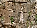
Depiction of the royal family of King Hanni at a holy spring in Eschkaft-e Salman
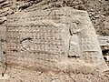
A religious ceremony with offerings


climate
|
Average monthly temperatures and rainfall for Izeh
Source: weather.ir
|
||||||||||||||||||||||||||||||||||||||||||||||||||||||||||||||||||||||||||||||||||||||||||||||||||||||||||||||||||||||||||||||||||||||||||||||||||||||||||||||||||||||||||||||||||||