Karun-3
| Karun-3 | |||||||
|---|---|---|---|---|---|---|---|
| The Karun-3 dam | |||||||
|
|||||||
|
|
|||||||
| Coordinates | 31 ° 48 '8 " N , 50 ° 5' 42" E | ||||||
| Data on the structure | |||||||
| Construction time: | 1994-2004 | ||||||
| Height above valley floor: | 185 m | ||||||
| Height above foundation level : | 205 m | ||||||
| Height of the structure crown: | 850 m | ||||||
| Building volume: | 1.3 million m³ | ||||||
| Crown length: | 831 m (?) | ||||||
| Crown width: | 5.5 m | ||||||
| Base width: | 29 m | ||||||
| Power plant output: | 2000 MW | ||||||
| Data on the reservoir | |||||||
| Altitude (at congestion destination ) | 845 m | ||||||
| Water surface | 48 km² | ||||||
| Storage space | 2970 million m³ | ||||||
| Design flood : | 13,300 m³ / s | ||||||
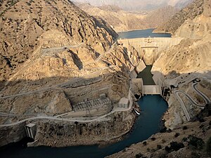
Karun-3 is the name of a large dam on the river Karun in the province of Khuzestan in Iran , which was built to generate electricity and completed of 2004. On November 8, 2004 , it was inaugurated and dammed in the presence of the energy minister.
The Karun is the richest, longest and only navigable river in Iran. The dam of the 60 km long reservoir is an arch dam and is located 28 km east of Izeh , 140 km from Ahvaz and 120 km upstream of the Karun-1 dam ( Shahid Abbaspur dam ). Planning for the project began in 1978 and was carried out by an Iranian-Canadian joint venture. The dam was built on solid, calcareous, marly sedimentary rock in the seismically active western Zagros Mountains .
The dam has three flood reliefs with discharge rates of 8700, 1500 and 2800 m³ / s, a total of 13,300 m³ / s. The power plant cavern , in which eight Francis turbines and generators with a capacity of 250 MW each (together 2000 MW) are housed, is located 500 m below the dam wall in the bedrock. It has the dimensions length × width × height = 250.40 m × 25.43 m × 47.70 m.
Instead of 831 m, the crown length is also given as 388 or 462 m.
See also
- List of the largest dams on earth
- List of the largest reservoirs on earth
- List of power plants in Iran
- List of dams in the world (Iran)

