
Seismics
The seismics (also Geoseismik ; from ancient Greek σεισμός SEISMOS "[earth] vibration, earthquake") is a branch of applied geophysics . It includes methods that explore the upper crust of the earth using artificially excited seismic waves and depict them graphically or digitally. A distinction is made between land seismics, which are used on the mainland , and sea seismics, which are used on water surfaces .
In contrast to this, seismology deals with the structure of the deep interior of the earth and earthquake research using similar methods, but which mainly use natural seismic sources, the earthquakes .
Methods
In seismics , a distinction is made between three different methods, which differ fundamentally in terms of data acquisition, but above all in terms of the evaluation process.

- Reflection seismics : Measurement and interpretation of the energy and transit times of seismic waves that are reflected at separating layers in the subsurface. Reflections occur when the acoustic impedance in the subsurface changes.
- Refraction seismics : Measurement and interpretation of the transit times of seismic waves that are broken ( refracted )at separating layers in the subsurfaceand thenpropagateas a head wave along these separating layers.
- Surface wave seismics : Measurement and interpretation of the dispersion, i.e. the dependence of the speed of propagation on the frequency, of seismic surface waves .
In special applications, for example for borehole measurements , sound sources and / or sensors can also be arranged vertically (VSP: Vertical Seismic Profiling ).
In order to better explore geological structures, the results of refraction seismics are combined with those of reflection seismics in a suitable manner. With so-called hybrid seismics , the respective inadequacies of one method are compensated for by the advantages of the other.
By far the most frequently used method is reflection seismics. It is mainly used in the search for crude oil and natural gas with high spatial resolution and positional accuracy. Since around 1990, more and more engineering-geological issues have been solved with reflection seismics. Refraction seismics, for its part, is used for special questions, since the late 1980s primarily for research into the large-scale structure of the earth's crust (down to below the Mohorovičić discontinuity ) as well as for engineering geological and geotechnical applications.
Applications
Seismics are used in the following areas:
- Basic research (how is the subsurface built)
- Exploration and prospecting of raw materials (crude oil, natural gas, groundwater, thermal and mineral water, building materials, gravel / sand / clay etc.)
- Underground studies for engineering structures (e.g. tunnels, foundations, landfills , cavity detection , geothermal power plants )
- Hazard analyzes for sites of contaminated sites (e.g. delimitation of a landfill, locating groundwater flows)
- Mapping of natural hazards (e.g. slope instabilities, landslides ).
Areas of application
Land seismics
In so-called land seismics , hammer blows , drop weights, blasting cartridges, explosions ("explosive seismics") or heavy trucks with vibrating machines ( vibroseis method) at so-called shooting points serve as sources of excitation . The signal is usually recorded with geophones , more rarely with seismometers or acceleration sensors ( accelerometers ), which are positioned along profile lines or flat.
Seismics
Seismic measurements on the free water surface are generally referred to as sea seismics . In the past, explosions were also set off to generate the necessary sound waves. However, this was time-consuming and dangerous. Therefore almost exclusively airguns (today be Airgun ) used. The measurements are made with hydrophones , which are usually pulled through the water on streamers behind one or more measuring vessels. The streamer is a tube several kilometers long, filled with several hundred hydrophones for recording reflected sound waves.
Transition zone water-land (transition zone)
Measurements can also be carried out on land and at sea. For example, geophones are installed on land, while hydrophones are used in the water. In this way, in marshes or mudflats to work.
For special tasks, so-called OBS ( Ocean Bottom Seismometers ) can also be sunk on the sea floor, which also register the sound waves there.
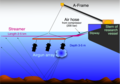
Arrangement of air pulsers and streamers at the stern to record a geophysical profile

Air gun for generating sound waves for marine seismics

Winch with streamer to record the reflected waves

Ocean bottom seismometer OBS in the pressure cylinder (open)


Application area
Seismics is used to answer questions about different depths, whereby the boundaries are diffuse and do not differ due to fundamentally different measurement methods.
- Ultra-high-resolution seismics: in engineering and archaeometry up to a depth of approx. 20 m, station spacing 5 to 20 cm in reflection seismics, 2 to 3 m for surface wave analysis
- High-resolution seismic: up to approx. 300 m depth, station spacing approx. 1 to 3 m
- “Normal” seismic: up to approx. 6 km depth, station spacing up to 50 m
- Crustal seismic: up to max. 100 km depth, distance between stations several 100 meters to tens of kilometers
Effects of seismic surveys on wildlife
The operation of seismic sources can be disruptive, harmful and under certain circumstances also fatal for marine animals in their catchment area because of the noise . Important parameters here include the frequency spectrum and the sound pressure of a seismic source. Different animal species react very differently to certain frequency spectra. The shots are usually fired every few seconds, the sound pressure level can reach up to 270 dB .
Animals are also greatly disturbed by ship noise.
literature
- Hans Berckhemer : Fundamentals of geophysics. 2., through and corrected edition. Scientific Book Society, Darmstadt 1997, ISBN 3-534-13696-9 .
- WM Telford, L. P. Geldart, R. E. Sheriff: Applied Geophysics. 2nd Edition. Cambridge University Press, Cambridge 2010, ISBN 978-0-521-33938-4 (English).
- R. Kirsch, W. Rabbel: Seismic methods in environmental geophysics. In: Martin Beblo (Ed.): Environmental geophysics. Ernst & Sohn Verlag for Architecture and Technical Sciences, Berlin 1997, ISBN 3-433-01541-4 .
- K. Krammer: Investigations of contaminated sites in former gravel pits with the help of refraction seismics. In: Martin Beblo (Ed.): Environmental geophysics. Ernst & Sohn Verlag for Architecture and Technical Sciences, Berlin 1997, ISBN 3-433-01541-4 .
Web links
- Marita Stevens: Seismics - In Search of Natural Gas. (PDF; 203 kB) (No longer available online.) In: bveg.de. Wirtschaftsverband Erdöl- und Erdgasgewinnung e. V. , Hanover, August 27, 2006, archived from the original on December 1, 2016 (PDF link to the flyer).
Individual evidence
- ↑ Peter Jaeggi : Noise Hell Ocean - The acoustic pollution kills whales. SWR2 Knowledge, October 17, 2008; Script ( RTF ; 13 kB); Audio. (mp3) (No longer available online.) Archived from the original on September 14, 2012 ; Retrieved on September 18, 2018 (37.3 MB; 26:35 min; the first two short speaker contributions are missing).
- ↑ science.ORF.at/APA/dpa: Ship noise disrupts foraging. In: science.orf.at. August 10, 2016, accessed September 18, 2018.