
Jäthensee
| Jäthensee | ||
|---|---|---|

|
||
| Jäthensee with Havel outflow | ||
| Geographical location | District of Mecklenburg Lake District | |
| Tributaries | Havel from the Zotzensee | |
| Drain | Havel to Görtowsee | |
| Places on the shore | none | |
| Location close to the shore | Babke | |
| Data | ||
| Coordinates | 53 ° 21 '8 " N , 12 ° 54' 19" E | |
|
||
| Altitude above sea level | 59.4 m above sea level NHN | |
| surface | 1.83 km² | |

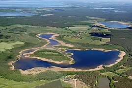
The Jäthensee is a lake in the municipality of Mirow in the Mecklenburg Lake District in Mecklenburg-Western Pomerania . The heavily indented lake is divided into two striking basins by the 24.2 hectare island of Schulzenwerder . The west basin is narrow and elongated and also divided into smaller basins. The east basin is wider. The lake is 2000 meters long and up to 1700 meters wide. In the east basin, the Havel flows into the north to leave the lake again in the east. This is a popular paddling water here. The lake shore is swampy and unforested.
The Jäthensee is located in the Müritz National Park .
The lake was mentioned in a document as early as 1258. The name is derived from the Old Slavic word gatĭ for dam or canal . The name means something like with channel, provided with derivative .
Jäthensee from the SE

sunset

inflow


