Jüdemerstrasse
| Jüdemerstrasse | |
|---|---|
| Street in Trier | |
| Basic data | |
| place | trier |
| District | center |
| Connecting roads | Karl-Marx-Strasse , Fahrstrasse |
| Cross streets | Heinz-Tietjen-Strasse, Antoniusstrasse, Stresemannstrasse |
| Places | Cattle marketplace |
The Jüdemerstraße is a street in the Trier city center . It runs from the driveway past the Viehmarktplatz to Karl-Marx-Straße .
history
The street name has been documented as juxta murum Judaeorum since 1240 . From 1350 it was called vicus juxta Judenmure . The eponymous Jewish wall took its name from the Jewish cemetery that it enclosed. This was east of the church of St. Antonius and took up part of today's cattle market.
When Archbishop Otto von Ziegenhain expelled the Jews from the city in 1418, the cemetery came into the possession of the sovereign and it fell into disrepair. In 1517 Philipp von Sierck made this property a fief . In 1615 it was finally given to the Capuchin Order to expand their garden after the Jews were allowed to return to the city and they laid their cemetery outside the city wall. Today the Jewish cemetery of Trier is located between Gilbertstrasse and Weidegasse.
Cultural monuments
While there are no other cultural monuments in Jüdemerstraße apart from the Hercules Fountain, many former town houses from the 18th and 19th centuries lined the street before they were destroyed in World War II . The Hercules fountain has only been in the shadow of the Antonius parish church since 1960 and dates from around 1800. The fountain figure shows Hercules fighting the lion and was created as early as 1730.
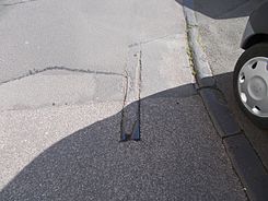
In addition, a remnant of the Trier tram , which was shut down in 1951 and protruding from the asphalt, could be seen in Jüdemerstrasse until around 2018 .
Two of the destroyed buildings are described in more detail below:
Former town house number 5
The building in Jüdemerstraße 5 came from the Baroque - builder Jacobus Steinem , who also built many other buildings in Trier. The building was characterized by smooth arched window frames with apex stone, mansard roof, corner pilasters. The building had four axes and two storeys and was also characterized by elements of the Rococo .
Former town house at number 12
From 1797 the family of the later town architect Johann Georg Wolff lived in the town house in Jüdemerstraße 12 . It was kept very simple with two storeys and four unadorned window axes. The large mansard roof made the building appear older than it actually was. The only dating reference was on the portal, because it shows shapes similar to the house in Simeonstraße 15 from the Napoleonic Empire period. At the portal there were also Egyptian lotus capitals that were flanked by two smooth pilasters. It was also decorated by an overlying entablature with a palmette frieze and two flanking lion heads. The door leaf also had typical almond and diamond-shaped empire ornamentation.
literature
- Patrick Ostermann (arrangement): Cultural monuments in Rhineland-Palatinate. Monument topography Federal Republic of Germany. Volume 17.1: City of Trier. Old town. Werner, Worms 2001, ISBN 3-88462-171-8 .
- Ulrike Weber (edit.): Cultural monuments in Rhineland-Palatinate. Monument topography Federal Republic of Germany. Volume 17.2: City of Trier. City expansion and districts. Werner, Worms 2009, ISBN 978-3-88462-275-9 .
- General Directorate for Cultural Heritage Rhineland-Palatinate (publisher): Informational directory of cultural monuments of the district-free city of Trier. (PDF; 1.2 MB) Koblenz 2010.
- Kulturbüro der Stadt Trier (ed.) / Emil Zenz: Street names of the city of Trier: their sense and their meaning. Trier 2003.
Individual evidence
- ↑ a b Kulturbüro der Stadt Trier (ed.) / Emil Zenz: Street names of the city of Trier: their sense and their meaning . Trier 2003.
- ^ Patrick Ostermann (arrangement): Cultural monuments in Rhineland-Palatinate. Monument topography Federal Republic of Germany. Volume 17.1: City of Trier. Altstadt.Werner, Worms 2001
- ↑ Helmut Lutz: Directory of the listed buildings since 1930. Preservation of monuments in Trier (1975) Ed .: Urban preservation of monuments
- ↑ Frey, J. 1993: Brunnen in Trier.
- ↑ a b Michael Zimmermann: Classicism in Trier. The city and its bourgeois architecture between 1768 and 1848. WVT Wissenschaftlicher Verlag Trier, 1997, ISBN 3-88476-280-X
Coordinates: 49 ° 45 ′ 11.7 " N , 6 ° 38 ′ 11.3" E
