Jabal Arkanu
| Jabal Arkanu | ||
|---|---|---|
|
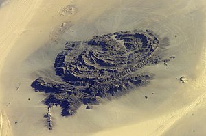
Satellite photo from Jabal Arkanu |
||
| height | 1435 m | |
| location | in the border triangle of Egypt , Libya and Sudan | |
| Coordinates | 22 ° 15 '5 " N , 24 ° 42' 12" E | |
|
|
||
The Jabal Arkanu ( Arabic جبل أركانو, also Jebel Arkenu , Gebel Árchenu ) is a 1435 m high mountain in the Libyan part of the Libyan desert about 50 km west of the border with Egypt and northwest of the border with Sudan . The mountain sits on the plateau base of the Gilf el-Kebir and towers above it by 500 m. About 250 km northwest of Jabal Arkanu are the Kufra oases .
geology
Seen from the air, the mountain formation is reminiscent of the structures of the ring complex of the nearby Uwainat . The Jabal Arkanu is geomorphologically a granitic intrusion with a broken interior. The mountain is drained by a system of small wadis that flow into a main wadi. The main wadi is very distinctive and runs in a north-south direction. The vegetation it contains consists of bushes, grasses and a few trees. The wadi therefore serves the Bedouins as grazing land for their cattle. To do this, they block the exit of the valley after they have driven the cattle in with stones and return about three months later to pick up their cattle. In the northeast of the massif is the heavily eroded remnant of a sandstone massif next to a granite dome.
The two Arkenu craters in the municipality of al-Kufra are located about 70 km west of Jabal Arkanu .
The landforms of this region of Africa are often associated with territories that can be seen on the surface of Mars . In the Gilf el-Kebir plateau, NASA found a landscape on earth that was comparable to the photos of Mars made for scientific purposes. For a long time, their seclusion did not allow the creation of map directories. A uniform map series was not created until the 1970s.
Research history
The Jabal Arkanu became known in 1892 for its small springs; the mountain itself was first explored in December 1922/1923 by Ahmed Hassanein. In September 1924, Hassanein followed up his report on exploration of water springs and rock carvings in National Geographic Magazine , the National Geographic Society, with 47 photos and cartographic records of the Arkanu and Uwainat areas before his book The Lost Oasis was published. In August 1962 the Royal Military Academy, Sandhurst undertook an expedition into the massif to undertake petroglyphic and geomorphological studies.
literature
- LV Bertarelli: Guida d'Italia Vol. XVII . Milan 1929 (Consociazione Turistica Italiana.).
- Hassanein Bey, A [hmad] M [uhammad]: Riddle of the desert . Brockhaus, Leipzig 1926 (translation of the novel "Lost Oases".).
- Siliotti, A [lberto]: Gilf Kebir National Park . Geodia, Verona 2009. ISBN 978-8887177862 .
Individual evidence
- ↑ Geography of the Libyan Desert -> Jebel Arkenu
- ↑ Eyes upon Earth, Jabal Arkanu, Libya
- ↑ A. Siliotti (see Ref.), P. 17
- ^ Bertarelli, LV (1929). Guida d'Italia, Vol. XVII (in Italian). Milano: Consociazione Turistica Italiana, p. 515
- ^ Williams / Hall, Recent Expeditions to Libya from the Royal Military Academy , Sandhurst

