
Al-Kufra municipality
| Municipality of al-Kufra - الكفرة | |
|---|---|
| Capital | al-Jauf |
| Residents | 50,104 (as of 2006) |
| surface | 483,510 km² |
| Population density | 0.1 inhabitants per km² |
| Coordinates | 24 ° 0 ′ N , 23 ° 0 ′ E |
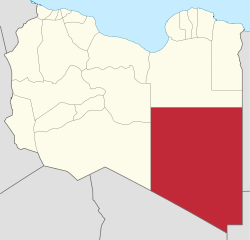
| map | |
  |
|


al-Kufra , Arabic الكفرة, DMG al-Kufra , is a municipality located in the southeast of the Libyan Arab Republic . It occupies the entire south of the historical Great Province of Kyrenaica .
geography
The capital of al-Kufra is al- Jawf (Al Jawf) in the area of the Kufra oases (8793 km²). There is a large oil refinery near the capital. 250 km northwest of the Kufra oases lies the Tazirbu oasis (6343 km²) (تزربر). The two oasis areas also define the two districts ( shabyat ) of the municipality.
In addition to the two large oasis areas, there are also smaller oases or groups of oases in the municipality:
- Rabyānah (ربيانة) (Erbehna) (314 km²)
24 ° 16 '27 " N , 22 ° 0' 46" O 180 km west of the Kufra oasis basin and 170 km south-east of Tazirbu
- Bazīmah (بزيمة) (Buseima) (320 km²)
24 ° 55 '12 " N , 22 ° 3' 14" O 124 km northwest of the Kufra oasis basin and 120 km south-east of Tazirbu
- Zīghan (بئر زيغن) (Wadi Zighen, Sighen) (2054 km²)
25 ° 29 '53 " N , 22 ° 7' 4" O 168 km northwest of the Kufra oasis basin and 98 kilometers east of Tazirbu
In 2003, 51,433 people lived in the municipality of al-Kufra on an area of 483,510 km² at that time. Since the administrative reform in 2007, a northern strip has been assigned to the Munizip al-Wahat .
Today the municipality has the following limits to the other municipalities:
- Munizip Murzuq - West
- Al-Jufra Municipality - Northwest
- Munizip al-Wahat - North
- Al-Butnan Municipality - Northeast
In the east al-Kufra has a border with Egypt , in the southeast with Sudan and in the south with Chad .
In the south-west, the northern foothills of the Tibesti Mountains extend far into the region. In it lies the highest mountain in Libya, the 2,268 meter high Bikku Bitti . In the south are smaller parts of the province in the Chad Basin .
Individual evidence
- ^ Bertarelli (1929), p. 515.
- ↑ Meyer 1905
- ↑ Statoids.com
Benghazi | al-butnane | Darna | Al-Jebel al-Achdar | al-Jebel al-Gharbi | al-Jifara | al-Jufra | Ghat | al-Kufra | al-Marj | Misrata | al-Murgub | Murzuq | Nalut | an-Nuqat al-Chams | Sabha | Surt | Tripoli | Wadi al-Haya | Wadi ash-Shati ' | al-Wahat | az-Zawiya