
Breitenbrunn hunting lodge


The electoral hunting lodge Breitenbrunn (coll. Jagdschloss Breitenbrunn ) in the Ore Mountains community of the same name was converted from a watchtower , which was probably built in the 13th or 14th century, is now a ruin under monument protection and is a landmark of the place.
Description and history
The complex in the southwest of the church at the upper end of the town of Breitenbrunn probably goes back to a watchtower with a moat from the founding time of the Schwarzenberg rule , which was the starting point for the settlement of the community. Its name is said to be derived from the moat in which there was a spring ( wide well ).
On the slightly warped, rectangular, walled core work with a floor plan of about 13 by 20 meters was the tower (today tower ruin) of about 9 by 9 meters. The core plant plateau is about 1 to 1.5 meters above the water surface. In front of it there is a circumferential, water-bearing ditch about 3 meters wide, which is additionally walled on the outside.
After a Vorwerk of the Schwarzenberg rulership was first built and later a settlement was built, the watchtower was converted into a hunting lodge, as well as accommodation and storage for hunting utensils. The building, which was also used as the forester's house, burned down in 1610, including the newly added third floor and attached Wendelstein, and in 1617, was rebuilt and, apparently unused, fell into ruin after 1700.
In 1959 the complex was placed under protection as a historical monument . The attached park is used regularly for local festivities, especially the fair.
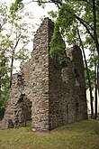
Views
- The ruins of the former electoral hunting lodge

View from the northeast

View from the northwest

View from the southwest
View from the southeast
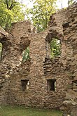
Inner wall east side

Detail of the interior

Wooden bridge and pavilion


literature
- Volkmar Geupel : The protected ground monuments in the Karl-Marx-Stadt district (= small writings of the State Museum for Prehistory Dresden. H. 3, ISSN 0232-5446 ). State Museum for Prehistory, Dresden 1983.
- Gottfried Barthel: 600 years of Breitenbrunn. In: Erzgebirgische Heimatblätter . 4, 1980, ISSN 0232-6078 , pp. 92-93.
Web links
Individual evidence
- ^ Friedrich H. Hofmann : Rittersgrün and Breitenbrunn in the Erzgebirge. From the history of both places and their postal system. Sächsisches Schmalspurbahn-Museum, Rittersgrün 2005, ISBN 3-937190-07-4 , pp. 107-109.
- ↑ Description of the facility in Volkmar Geupel: The protected ground monuments in the Karl-Marx-Stadt district. 1983, pp. 71-72.
- ^ Friedrich H. Hofmann: Rittersgrün and Breitenbrunn in the Erzgebirge. From the history of both places and their postal system. Saxon Narrow Gauge Railway Museum, Rittersgrün 2005, ISBN 3-937190-07-4 , p. 109.
Coordinates: 50 ° 28 ′ 32.8 " N , 12 ° 46 ′ 17.9" E