
Tordoia
| Tordoia municipality | |||
|---|---|---|---|
| coat of arms | Map of Spain | ||

|
|
||
| Basic data | |||
| Autonomous Community : |
|
||
| Province : | A Coruña | ||
| Comarca : | Ordes | ||
| Coordinates | 43 ° 6 ′ N , 8 ° 36 ′ W | ||
| Area : | 124.55 km² | ||
| Residents : | 3,299 (Jan 1, 2019) | ||
| Population density : | 26.49 inhabitants / km² | ||
| Postal code : | 15683 | ||
| Municipality number ( INE ): | 15084 | ||
| Location of the municipality | |||

|
|||

Tordoia (Spanish: Tordoya) is a small Spanish town between Santiago de Compostela and A Coruña in Galicia . It has an area of 125 km² and an overall decreasing population of 3299 (as of January 1, 2019). Various rock exclusions called “Pedra Longa” come to the surface at the site. It is also home to one of the best preserved dolmens in the Dolmen of Cabaleiros region and the Anta, popularly known as the Casa da Moura . It has a 4.6 m long ceiling plate and six bearing stones.
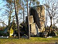
Pedra Longa

Pedra Longa
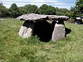
Casa da Moura


Results of the municipal council elections
| Political party | Seats 2011 | Seats 2015 |
|---|---|---|
| PP | 8th | - |
| PSOE | 3 | - |
Source:
Economy of Galicia
| Employees | Percentage | ||||
|---|---|---|---|---|---|
| TOTAL | 1271 | 100 | |||
| Agriculture, livestock and fishing | 388 | 22.66 | |||
| Industry | 214 | 18.84 | |||
| Construction industry | 147 | 11.57 | |||
| Service companies | 522 | 41.07 | |||
| * Data from the Statistical Office for Economic Development in Galicia , IPI | |||||
Population development of the municipality

Individual evidence
- ↑ Cifras oficiales de población resultantes de la revisión del Padrón municipal a 1 de enero . Population statistics from the Instituto Nacional de Estadística (population update).
- ^ Election results on the website of the Spanish Ministry of the Interior; accessed on August 3, 2019
Web links
Abegondo | Ames | Aranga | Ares | Arteixo | Arzúa | A Baña | Bergondo | Betanzos | Boimorto | Boiro | Boqueixón | Brión | Cabana de Bergantiños | Cabañas | Camariñas | Cambre | A Capela | Carballo | Cariño | Carnota | Carral | Cedeira | Cee | Cerceda | Cerdido | Coirós | Corcubión | Coristanco | A Coruña | Culleredo | Curtis | Dodro | Dumbría | O Pino | Fene | Ferrol | Fisterra | Frades | Irixoa | A Laracha | Laxe | Lousame | Malpica de Bergantiños | Mañón | Mazaricos | Melide | Mesía | Miño | Moeche | Monfero | Mugardos | Muros | Muxía | Narón | Neda | Negreira | Noia | Oleiros | Ordes | Oroso | Ortigueira | Outes | Oza-Cesuras | Paderne | Padrón | A Pobra do Caramiñal | Ponteceso | Pontedeume | As Pontes de García Rodríguez | Porto do Son | Rianxo | Ribeira | Rois | Sada | San Sadurniño | Santa Comba | Santiago de Compostela | Santiso | Sobrado | As Somozas | Teo | Toques | Tordoia | Touro | Trazo | Val do Dubra | Valdoviño | Vedra | Vilarmaior | Vilasantar | Vimianzo | Zas