
Malpica de Bergantiños
| Malpica de Bergantiños municipality | |||
|---|---|---|---|
 View from Cabo San Hadrián on the place
|
|||
| coat of arms | Map of Spain | ||
.svg)
|
|
||
| Basic data | |||
| Autonomous Community : |
|
||
| Province : | A Coruña | ||
| Comarca : | Bergantiños | ||
| Coordinates | 43 ° 19 ′ N , 8 ° 49 ′ W | ||
| Height : | 21 msnm | ||
| Area : | 61.22 km² | ||
| Residents : | 5,391 (Jan 1, 2019) | ||
| Population density : | 88.06 inhabitants / km² | ||
| Postal code : | 15113 | ||
| Municipality number ( INE ): | 15043 | ||
| Nearest airport : | A Coruña airport 54 km | ||
| administration | |||
| Mayor : | Eduardo Parga ( PP ) | ||
| Address of the municipal administration: | Rúa Emilio González López, 1, 15113 Malpica de Bergantiños, Tel .: +34 981 72 00 01 | ||
| Website : | concellomalpica.com | ||
| Location of the municipality | |||

|
|||

Malpica de Bergantiños is a municipality in the Galician province of A Coruña in north-western Spain . The place is located on the north-west Spanish Atlantic coast about 50 km west of the provincial capital A Coruña . It marks the northeastern end of the Costa da Morte , a stretch of coast that extends from there to Cape Finisterre . Malpica has a fishing port.
Districts ( Parroquias )
|
|
politics
| Political party | 2015 | 2011 | ||
|---|---|---|---|---|
| Be right % | Seats | Be right % | Seats | |
| PP | 44.49 & | 7th | 38.07% | 6th |
| PSOE | 12.58% | 1 | 28.42% | 4th |
| BNG | 7.75% | 1 | 13.68% | 2 |
| AIM | 28.64% | 4th | 12.55% | 1 |
economy
| Employees | Percentage | ||||
|---|---|---|---|---|---|
| TOTAL | 1,875 | 100 | |||
| Agriculture, livestock and fishing | 356 | 18.99 | |||
| Industry | 419 | 22.35 | |||
| Construction industry | 241 | 12.85 | |||
| Service companies | 859 | 45.81 | |||
| * Data from the Statistical Office for Economic Development in Galicia , IPI | |||||
Population development of the municipality

history
The first written mention dates from the 13th century; Malpica is referred to as the property of the Archdiocese of Santiago de Compostela . In the 15th century, Sancho de Ulloa, Count of Monterrei , wrested the place from the diocese and incorporated it into their own property.
In the 17th century, Cardinal Hoyo described fishing on the spot, in which immigrant fishermen from the Basque Country and Cantabria also took part. The fishermen had to hand over shares of their catch as a donation to the bishopric. Wood carvings depicting fish are often found in the roof beams of old mills and fishermen's houses from that time.
Malpica was the center of Galician whaling until the end of the 19th century . According to the chronicler Jerónimo del Hoyo, most whales were landed there in the 17th century. Due to its importance, it was the seat of the maritime authority Axudantía de Mariña until 1895 . Their headquarters were later moved to Ponteceso and later to Corme . With the decline of whaling, dangerous coastal fishing with small cutters under sails shifted. With the advent of fish canning factories, fishing flourished. If the local fishing grounds provided no income, it was fishing in the estuary of Muros .
port
Nowadays Malpica is the home port of a large number of fishing boats. The port offers a modern infrastructure with a new cold store, a large fish market and a flood gate behind which smaller ships find shelter.
In its current form, the port was built in 1931 based on designs by the engineer Emilio González López.
Sights and excursion destinations
Historic town center

Like Caión , Corme , Laxe , Camelle and Camariñas , Malpica is a typical fishing village on the Costa da Morte. In the narrow streets of the town center, only a few old fishermen's houses have been preserved in the middle of the otherwise unattractive, box-shaped city architecture. They are only single-story, in order to withstand the often strong wind better, made of masonry that is reinforced at the corners and the building openings. The multi-storey houses with closed balconies behind a glazed wooden facade that are typical of Galicia can also be found in Malpica. They mostly belonged to wealthy boater families.
On the Praza do Cruzeiro there is a stone cross, which is decorated with relief sculptures on all four sides. At this point there has always been a well from which the city's residents could get water.
Cabo Santo Hadrián and Islas Sisargas
The Islas Sisargas , north-west of the city in front of Cabo Santo Hadrián , are a sanctuary for endangered bird species such as the Iberian guillemot . They are not accessible to visitors, but can only be seen from the cape about 2 km away.
The pilgrim chapelErmita do Santo Hadriánis located on the eastern slope of the cape . It was built near a spring in the late 16th and early 17th centuries.
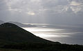
Sunset at Cabo de Santo Hadrián
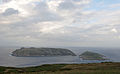
Islas Sisargas

Ermita Santo Hadrián


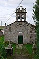
Vilanova de San Tirso
The Parroquía Vilanova de San Tirso is located on the edge of the forest two kilometers south of the port .
The baroque parish church and its adjacent rectory were built in the 18th century. The portal facade of the church is crowned by a church tower that is broken by two round arches. The bells hang in them. The altarpiece inside also dates from the Baroque period.
Mens
The Parroquía Mens is located 8 km west-southwest of Malpica.
On the connecting road DP-4307 east of the small town are theTorres de Mens, the towers of Mens. The noblemanLope Sánchez de Moscosohad it built as a defensive bulwark against church troops in the 15th century. In them theArchbishop of Santiago wasimprisoned. Only one tower, the so-calledBergantiñana, remains. The facility was rebuilt from 1998. It is privately owned and only accessible from the outside.
In the forest around one kilometer northeast of the towers is the Capela do Espírito Santo , the Chapel of the Holy Spirit. The simple little church was built at the end of the 18th century and restored in 1994. In the 19th century, the bones of Saint Calixto were brought from Rome and buried in the chapel.

Torres de Mens

Capela do Espírito Santo


Barizo
The Parroquería Barizo 8 km west of Malpica has a small port, a fine sandy shallow beach and a beach restaurant with a Michelin star .

Barizo. In the background the Islas Sisargas
Parish Church of San Pedro

port

Beach


Punta Nariga
The Punta Nariga is a headland about 5 km northwest of Barizo . It can be reached from Barizo or from Mens via a narrow, winding mountain road. This leads through predominantly sparse forest and in the exposed areas through rocky heather.
Snakes, lizards, crows, magpies, kestrels and small game such as quails, rabbits and snipes populate the peninsula. The San Miro Hunting Company has the right of use; she cherishes and hunts rabbits and partridges there.
The name Nariga is derived from the Latin Narica , nose. from. The 39 m high lighthouse was designed by César Portela in 1995 and went into operation in 1997. Its light has a range of around 22 nautical miles or 41 km. An Atlante sculpture by the artist Manolo Coia adorns the lake-side top of the viewing terrace at the foot of the lighthouse.

Punta Nariga

Rock formation at Punta Nariga, approx. 4 m high

Atlante


.jpg)
Individual evidence
- ↑ Cifras oficiales de población resultantes de la revisión del Padrón municipal a 1 de enero . Population statistics from the Instituto Nacional de Estadística (population update).
- ↑ 2015 Spanish Ministry of the Interior ( page no longer available , search in web archives ) Info: The link was automatically marked as defective. Please check the link according to the instructions and then remove this notice.
- ↑ 2011 Spanish Ministry of the Interior
- ↑ a b c d Historia , website of the municipal administration, accessed on November 6, 2014
- ↑ a b c d Núcleo histórico de Malpica , website of the municipality, accessed on November 6, 2014
- ↑ Tobias Büscher: Galicia & Jacobsweg. DuMont travel pocket book, Ostfildern, 2014, p. 214. ISBN 978-3-7701-7397-6
- ↑ Information board on site
- ↑ a b c De Santiso a Mens , website of the municipality, accessed on November 7, 2014
- ↑ De Asalo ao Faro Nariga , website of the municipality, accessed on November 7, 2014
- ↑ Information board on site
Web links
Abegondo | Ames | Aranga | Ares | Arteixo | Arzúa | A Baña | Bergondo | Betanzos | Boimorto | Boiro | Boqueixón | Brión | Cabana de Bergantiños | Cabañas | Camariñas | Cambre | A Capela | Carballo | Cariño | Carnota | Carral | Cedeira | Cee | Cerceda | Cerdido | Coirós | Corcubión | Coristanco | A Coruña | Culleredo | Curtis | Dodro | Dumbría | O Pino | Fene | Ferrol | Fisterra | Frades | Irixoa | A Laracha | Laxe | Lousame | Malpica de Bergantiños | Mañón | Mazaricos | Melide | Mesía | Miño | Moeche | Monfero | Mugardos | Muros | Muxía | Narón | Neda | Negreira | Noia | Oleiros | Ordes | Oroso | Ortigueira | Outes | Oza-Cesuras | Paderne | Padrón | A Pobra do Caramiñal | Ponteceso | Pontedeume | As Pontes de García Rodríguez | Porto do Son | Rianxo | Ribeira | Rois | Sada | San Sadurniño | Santa Comba | Santiago de Compostela | Santiso | Sobrado | As Somozas | Teo | Toques | Tordoia | Touro | Trazo | Val do Dubra | Valdoviño | Vedra | Vilarmaior | Vilasantar | Vimianzo | Zas