
Muxia
| Muxía municipality | |||
|---|---|---|---|
| coat of arms | Map of Spain | ||

|
|
||
| Basic data | |||
| Autonomous Community : | Galicia | ||
| Province : | A Coruña | ||
| Comarca : | Fisterra | ||
| Coordinates | 43 ° 6 ′ N , 9 ° 13 ′ W | ||
| Area : | 121.19 km² | ||
| Residents : | 4,657 (Jan 1, 2019) | ||
| Population density : | 38.43 inhabitants / km² | ||
| Municipality number ( INE ): | 15052 | ||
| administration | |||
| Website : | www.concellomuxia.com | ||
| Location of the municipality | |||

|
|||

Muxía (officially and in Galician language ; unofficially Spanish and formerly officially Mugía ) is a municipality in the Galician province of A Coruña in north-western Spain .
geography
The place is on the Costa da Morte , a section of the north-west Spanish Atlantic coast . Cape Touriñán, the westernmost point of mainland Spain, belongs to the municipality .
Districts ( Parroquias )
|
|
history
The coast of Muxía was one of the hardest hit areas in the environmental disaster caused by the sinking of the Prestige oil tanker in November 2002 .
On the evening of December 25, 2013, a fire after a lightning strike during the Christmas storm destroyed the roof structure and part of the sanctuary of the Virxe da Barca (Marian shrine to the ship's maiden). The church is an important place of pilgrimage in Galicia and another destination of many pilgrims after reaching Santiago de Compostela.
Population development of the municipality


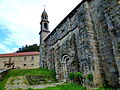
Former monastery church of St Julian Moraime

St Julian Moraime Pigeon House.

St Julian Moraime side portal
Former monastery church of St Julian Moraime side view

St Julian Moraime interior
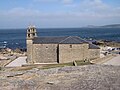
Santuario da Virxe da Barca

San Xulián de Moraime

Atlantic coast near Muxía

Muxia 2008

Pilgrimage church in Muxia

Chapel by the sea

Muxia Monument by Alberto Banuelos

Muxia lighthouse Costa del Morte

Muxia burial site
.JPG)
.JPG)
.JPG)
.JPG)
.JPG)


.JPG)
.JPG)
.JPG)
.JPG)
.JPG)
Web links
Individual evidence
- ↑ Cifras oficiales de población resultantes de la revisión del Padrón municipal a 1 de enero . Population statistics from the Instituto Nacional de Estadística (population update).
- ↑ Storm destroys historic church in northern Spain , spanien-bilder.com, undated
Abegondo | Ames | Aranga | Ares | Arteixo | Arzúa | A Baña | Bergondo | Betanzos | Boimorto | Boiro | Boqueixón | Brión | Cabana de Bergantiños | Cabañas | Camariñas | Cambre | A Capela | Carballo | Cariño | Carnota | Carral | Cedeira | Cee | Cerceda | Cerdido | Coirós | Corcubión | Coristanco | A Coruña | Culleredo | Curtis | Dodro | Dumbría | O Pino | Fene | Ferrol | Fisterra | Frades | Irixoa | A Laracha | Laxe | Lousame | Malpica de Bergantiños | Mañón | Mazaricos | Melide | Mesía | Miño | Moeche | Monfero | Mugardos | Muros | Muxía | Narón | Neda | Negreira | Noia | Oleiros | Ordes | Oroso | Ortigueira | Outes | Oza-Cesuras | Paderne | Padrón | A Pobra do Caramiñal | Ponteceso | Pontedeume | As Pontes de García Rodríguez | Porto do Son | Rianxo | Ribeira | Rois | Sada | San Sadurniño | Santa Comba | Santiago de Compostela | Santiso | Sobrado | As Somozas | Teo | Toques | Tordoia | Touro | Trazo | Val do Dubra | Valdoviño | Vedra | Vilarmaior | Vilasantar | Vimianzo | Zas