Johann Christoph Hurter

Johann Christoph Hurter (* around 1576 in Memmingen ; † around 1640 in an unknown location) was a German cartographer who probably worked all his life in his home town of Memmingen, where he was also the city architect. Nothing has come down to us about his immediate circumstances.
plant
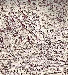
With the publication of a map of the entire Iller river basin ( Illerae Amnis ac utrinque adiacentis Alemanniae Geographica Descriptio. Descriptio of the Iller stream and the surrounding Algöws on both sides ) in 1619 Johann Christoph Hurter emerged as a cartographer for the first time. The work was engraved in copper by Raphael Custos (1590–1664) and was published in Augsburg and is considered the oldest cartographic representation of the Allgäu .
Other cartographic works by Hurter included a map of the entire Alemannic area ( Alemaniae sive Sueviae superioris Chorographia nova ); a map of the Rotenstein rule (located between Memmingen and Kempten ) and an atlas of Swabia ( Geographica provinciarum Sueviae descriptio ), which was probably only published posthumously and reissued several times until the 18th century.
Until well into the 18th century, Hurter's maps were repeatedly used by cartographers and engravers of different nationalities for their own work. The Alemannic map has often been copied by Dutch people such as Hendrik Hondius (1573–1650), Willem Blaeu (1571–1638) and Johann Jansson (1588–1664). French cartographers such as Guillaume Delisle (1675–1726) and Jean Baptiste Liébaux (1673–1744) also worked from maps by Hurter: Dressée sur les Memoires de Christ. Hurtem, d'Ausbourg.
reception
According to the German cartographer and geographer Ruthardt Oehme (1901–1987), Hurter's maps stand “between the pictorial land panels of the 16th century and the more abstract and generalized floor plans of the late 17th and 18th centuries”. His representation of the relief is exemplary, which can be clearly seen in the example of the map of the Iller river area, in which the foothills of the Alps and the hilly Allgäu region clearly stand out from each other. The rugged drawing of the mountains shows the influence of corresponding depictions on the Bavarian land tables by Philipp Apian (1531–1589).
source
- Johann Christoph Hurter: Geographica provinciarum Sueviae descriptio: Swabia presented in XXVIII matching tables (Atlas of Swabia), engravers Melchior Küsel and Johann Stridbeck the Elder, by Hanß Georg Bodenehr, Augsburg 1679. Bavarian State Library - Mapp. XII, 162b
literature
- Fritz Hellwig, Wolfgang Reiniger, Klaus Stopp: Maps of the Palatinate on the Rhine 1513–1803: Catalog of the printed maps with an introduction to map history , W. Reiniger, Bad Kreuznach 1984, ISBN 3-923714-01-7
- Ruthardt Oehme: The history of the cartography of the German southwest . Edited by the Commission for Historical Regional Studies in Baden-Württemberg. Work on the Historical Atlas of Southwest Germany , Volume 3, Jan Thorbecke, Konstanz and Stuttgart 1961.
Remarks
- ↑ In almost all sources 1619 is given as the year of birth, which is certainly due to a confusion between the cartographic creative period and the lifetime.
- ↑ Jean Baptiste Liébaux in the legend of his map Nouvelle Carte tres utile pour les Gens de Guerre from 1724, where the French military cartographer Henri Sengre is also mentioned.
- ↑ Ruthardt Oehme: The history of the cartography of the German Southwest (1961), p. 75.
Web links
- Literature by and about Johann Christoph Hurter in the bibliographic database WorldCat
- Index entry for Johann Christoph Hurter in the Deutsche Biographie
- Bavarian State Library Map of the Iller river area from 1619
- Google Books Atlas of Swabia (Augsburg 1679)
| personal data | |
|---|---|
| SURNAME | Hurter, Johann Christoph |
| ALTERNATIVE NAMES | Hurter, Johann C .; Hurtern, Johann Christoph; Hurten, Jean Christophe; Hutero, Christophoro |
| BRIEF DESCRIPTION | German cartographer |
| DATE OF BIRTH | around 1576 |
| PLACE OF BIRTH | Memmingen |
| DATE OF DEATH | around 1640 |
