
Kabara (Mali)
| Kabara Kabara |
|||
|---|---|---|---|
|
|||
| Coordinates | 16 ° 42 ′ N , 2 ° 59 ′ W | ||
| Basic data | |||
| Country | Mali | ||
| Timbuktu | |||
| circle | Timbuktu | ||
| ISO 3166-2 | ML-6 | ||

Kabara is a small town south of Timbuktu .
History and traffic
A 13-kilometer-long artificial canal connected Kabara with Timbuktu since the 17th century. The canal was used by pirogues and sailing ships . It served to transport people and goods and connected Timbuktu with the Niger . This canal has dried up again and again in modern times, is now silted up and only visible as a ditch in some places. About six kilometers southwest of Kabara there is a ferry dock on the north bank of the Niger. The Timbuktu airfield is located about three kilometers northwest of Kabara. An asphalt road connects Kabara with the ferry terminal and Timbuktu Airport .
Picture gallery
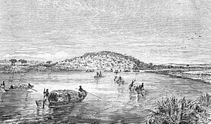
The Niger near Kabara (around 1855, after Heinrich Barth)

"In the camp before Kabara." (The German Emin Pascha expedition, before 1891)

Map of the Kabara Timbuktu Region (1896)

Ferry across the Niger (2003)


