
Quays

Quays were the quays at Hamburg's inland port that were built in the 14th century, and the name of a street in Hamburg's old town since 1900 is evidence of this. The quays as port facilities were located between the mouth areas of the Nikolaifleet and the Alsterfleet ; the associated roads Buten-Kajen and Binnen-Kajen ran from 1562 to 1887 between the Hohen Brücke / Deichstrasse and the Rödingsmarkt . This also corresponds to the location of today's 150-meter-long Kajen Street .
With the relocation of the port of Hamburg to the mouth of the Alster in the 13th century and the further expansion of the inland port in the 14th century, the quays were created as a dike with a ship landing stage at the port exit. The name on the maps at that time was Lütke Dyk , since 1465 the name Kajen has been used with the meaning of "Uferplatz" or "Hafendamm". When removing the fortification 1530 is moved into the roads in the area of the fortress line a, it was thus behind the Schaartor and the Stenen Hövede (Steinhöft), from an extended Schaarmarkt south stone wall with embrasures . After the new fortress construction of the Hamburg ramparts , the dike was removed in 1626 and rows of houses were built on the area, so that two narrow alleys were created, the butene quays on the water and behind them the inland quays , which were also referred to as the Achter de Kajen .
With the construction of the harbor basin on the Großer Grasbrook from 1860 and in particular with the establishment of the free port , the construction of the warehouse district and the customs canal from 1883, the transshipment point outside the duty-free limit changed its importance. The narrow rows of houses were demolished in 1887, the area gained was incorporated into the street on the edge of the harbor and the bank was converted into a flood protection system. After the last increase in 2010, the height of protection is between 7.60 meters and 8.68 meters above sea level .
The northern edge of the quays was redeveloped between 1953 and 1955 with five seven-story buildings, the so-called Kajen Kontorhausgruppe by the architect Otto Paradowski . The ensemble has been a listed building since 1997.
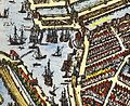
Quays at the inland port between Alsterfleet and Nikolaifleet, around 1600

Quays at the inland port, drawing from 1885
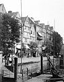
Butenkajen before the demolition in 1887
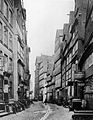
Inland quays before demolition in 1887


Individual evidence
- ^ Ernst Christian Schütt: Chronik Hamburg , 2nd updated edition, Bertelsmann Lexikon Verlag, Gütersloh Munich 1997, ISBN 3-577-14443-2 , p. 258.
- ^ Christian Hanke: Hamburgs street names tell history, Hamburg 2006, ISBN 3-929229-41-2 , p. 38.
- ↑ Plattdüütsch Eck: Bi de Mühren (PDF; 258 kB).
- ↑ Free and Hanseatic City of Hamburg - State Office for Roads, Bridges and Waters: Flood protection for Hamburg - Raising the dikes - Inland port / Schaartor , plan approval application from November 18, 2008 (PDF; 896 kB)
- ↑ Hamburg Monument Protection Office: Recognized monuments, p. 533 (PDF; 1.9 MB).