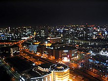
Kamata (Ōta)
|
Kamata district of Ōta |
|
|---|---|
| Coordinates | 35 ° 33 '50 " N , 139 ° 43' 15" E |
| Residents | 19,644 (Jan. 1, 2011) |
| Incorporation | Oct. 1, 1932 |
| Post Code | 144-0052 |
Kamata ( Japanese 蒲 田 ) is a district in the Ōta district of the Japanese capital Tokyo , but also a collective term for the area around the Kamata train station .
geography
In the administrative sense, Kamata refers to the district that is bounded to the west by the Keihin-Tōhoku line of the Kamata station and east by the Daiichi-Keihin expressway ( national road 15 ) or the parallel Keikyū main line with the Keikyū station Kamata . In the south it is bounded by the Kampachi-dōri expressway ( 環 八 通 り ; prefecture road 311), while in the north at the Tōhō University hospital, the border with the Ōmori-Nishi district lies.
West of the Keihin-Tōhoku line is Nishi-Kamata ( 西 蒲 田 , "West Kamata"), which is bounded further west by the Ikegami line , and south of the Kampachi-dōri is the Kamata-Honchō district ( 蒲 田 本 町 , "Kamata- Center"). With the colloquial term Kamata, these are usually included.
The Nomigawa ( 呑 川 , also Nomikawa ) flows through Kamata . East of the Keikyū main line connects to the north of Nomigawa Higashi-Kamata ( 東 蒲 田 , "East Kamata") and south of the Minami-Kamata River ( 南 蒲 田 , "South Kamata").
The Kamata district is the seat of the town hall of Ōta. The Kamata campus of the Tokyo University of Technology is located in Nishi-Kamata .
history
In the Edo period , many Japanese plum trees ( ume ) were found in the area of Kamata , which were also immortalized in the works of the artist Utagawa Hiroshige . For this reason, Kamata was also called Kamata Umeyashiki ("Ume Garden Kamata") and that is how a train station is still called Umeyashiki today. The ume is also the symbol of Ōta.
On 1 May 1889 the Japanese community being Western-style Kamata for village community (was in the reorganization 蒲田村 , Kamata- mura ) named. On October 10, 1922 , it was upgraded to a municipality ( 蒲 田 町 , Kamata- machi ). On October 1, 1932, Kamata and Haneda , Yaguchi and Rokugō were incorporated into the city of Tokyo and from these the Kamata district ( Stadt 田 区 ) was formed. This was merged on March 15, 1947 with Ōmori ( 大 森 zu , -ku ) to Ōta ( 大田 区 ), the name of which is derived from both precursor districts.
A movie studio was built in the community during the Meiji period . That is why Kamata was also called the "City of Film". Today, the station melody from JR Kamata station is the "Kamata March" ("Kamata March" is a song by the former film studio). Today the film studio is a concert hall.
At the end of the Second World War , Kamata was completely destroyed (March 15, 1945) and was rebuilt.
In 2012 the NHK - Dorama Umechan-Sense (teacher Ume-chan) was filmed in Kamata.
particularities
Kamata is known for its "black, hot springs " ( 黒 湯 , kuroyu ), as their water penetrates through layers of plant fossils and is therefore black in color. This water is obtained from the local bath houses ( Sento ) and some hotels for their baths.
Kamata's culinary specialty is the special “winged” Chinese dumplings (Japanese gyōza ) that can be found in the many Chinese restaurants in Kamata.
Web links
- Ōta website (Japanese)
Individual evidence
- ↑ a b Tokyo Eye: Kamata. (No longer available online.) NHK, July 13, 2011, archived from the original on July 14, 2014 ; accessed on June 12, 2014 . Info: The archive link was inserted automatically and has not yet been checked. Please check the original and archive link according to the instructions and then remove this notice.
