
Cape Soya

Cape Sōya ( Japanese 宗 谷 岬 Sōya-misaki ) is, apart from the small island of Benten-jima ( 45 ° 31 ′ 33 ″ N , 141 ° 55 ′ 10 ″ E ) 1 km off its coast, Japan's northernmost point. The cape is located on the island of Hokkaidō in Wakkanai in the sub-prefecture of Soya and protrudes into La Pérouse Street . On a clear day you can see as far as Sakhalin in Russia , which is 43 km away.
There are several monuments at Cape Soya:
- The "monument to the northernmost point of Japan" ( 日本 最 北端 の 地 の 碑 , Nihon saihokutan no chi no hi ) has the shape of a tetrahedron , which is supposed to stand for the North Star as a symbol of the north, with an "N" in the middle, which also stands for the north. The circular base in turn stands for peace and cooperation.
- The "Statue of Mamiya Rinzō " ( 間 宮 林 蔵 の 立 像 , Mamiya Rinzō no ritsuzō ) was erected in July 1980 for the 200th birthday of the explorer Mamiya Rinzō, who mapped Sakhalin and the region around the Tatar Sound.
- The "Tower of Prayer" ( 祈 り の 塔 , Inori no tō ) was opened on September 1, 1985 and commemorates the shooting down of Korean Airlines flight 007 and the victims by the Soviet air defense exactly two years earlier.
- The "Cape Sōya Musical Monument" ( 宗 谷 岬 音 楽 碑 , Sōya-misaki ongakuhi ) is a sculpture that plays the melody of the song Sōya-misaki , which made the Cape famous across the country. Part is a stone slab with the notes and text to sing along to. It was erected in November 1980.
- The "Friedensdenkmal" ( 平和 の 碑 , Heiwa no hi ) commemorates the crew of the submarine USS Wahoo , sunk in October 1943 , as well as the 690 victims of the five Japanese merchant ships torpedoed by it. The memorial was erected in September 1995 on the occasion of the 50th anniversary of the end of the war and was the first joint US-Japanese memorial.
Around the cape there are many “northernmost” facilities such as the northernmost lighthouse, the northernmost gas station and the northernmost elementary school. The northernmost station of Japan Railways , however, is 33 km away in Wakkanai .
photos
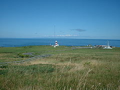
View from Cape Soya, across La Pérouse Street to Sakhalin
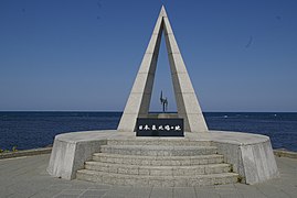
Monument to the northernmost point of Japan
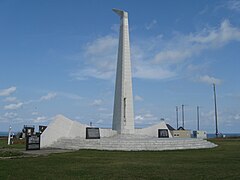
Inori no Tō in memory of Korean Airlines flight 007

Sculpture of the song Soya-misaki

Notes and lyrics of the song
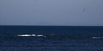
View from the bank to Sakhalin


Web links
Individual evidence
- ↑ 日本 最 北端 の 地 の 碑 . Wakkanai, accessed July 25, 2014 (Japanese).
- ↑ 間 宮 林 蔵 の 立 像 . Wakkanai, accessed July 25, 2014 (Japanese).
- ↑ 祈 り の 塔 . Wakkanai, accessed July 25, 2014 (Japanese).
- ↑ 宗 谷 岬 音 楽 碑 . Wakkanai, accessed July 25, 2014 (Japanese).
- ↑ 平和 の 碑 . Wakkanai, accessed July 25, 2014 (Japanese).
Coordinates: 45 ° 31 '22.6 " N , 141 ° 56' 11.7" E