La Pérouse Street
| La Pérouse Street | ||
|---|---|---|
| View from Cape Sōya , Hokkaidō , across La Pérouse Street to Sakhalin | ||
| Connects waters | Japanese sea | |
| with water | Sea of Okhotsk | |
| Separates land mass | Hokkaidō | |
| of land mass | Sakhalin | |
| Data | ||
| Geographical location | 45 ° 43 ' N , 142 ° 2' E | |
|
|
||
| length | 94 km | |
| Smallest width | 43 km | |
| Greatest depth | 118 m | |
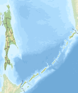
| Location of the strait between Sakhalin and Hokkaidō | ||
The La Perouse Strait ( Jap. 宗谷海峡 , Soya Kaikyo , Soya Strait ) is a strait that of the southern part of the Russian island of Sakhalin from the northern Japanese island of Hokkaido separates.
It connects the Sea of Japan in the west with the Sea of Okhotsk in the east. It is 94 km long and 43 km wide at the narrowest point. It is usually between 20 and 40 m deep, at the deepest point 118 m.
The street is named after Jean-François de La Pérouse , who explored the canal in 1787.
In June 2013, it was decided to build a railway tunnel (the Sakhalin-Hokkaidō Tunnel ) under La Pérouse Street. Work should start in 2016.
Individual evidence
- ^ Wheels set in motion for London-Tokyo train link ( Memento from June 8, 2013 in the Internet Archive ), Telegraph June 7, 2013


