Cape St. Charles
| Cape St. Charles | ||
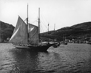
 Cape Charles 1908 |
||
| Geographical location | ||
|
|
||
| Coordinates | 52 ° 13 '35 " N , 55 ° 37' 15" W | |
| Waters 1 | Atlantic Ocean | |
The Cape St. Charles (. English Cape St. Charles , fr. Cape St. Charles , nor Elijah Point ) is a cape and a peninsula on the east coast of Labrador in Canada , between the Strait of Belle Isle to the south and the Labrador Sea in the North. It forms the easternmost point of the North American mainland.
It is located at the end of a 12 km long peninsula 15.5 km east of Lodge Bay commune at the mouth of the Saint Charles River , from which a path leads to the cape. From the community of Mary's Harbor it is about 23.5 km to the cape via Lodge Bay (initially on Route 510 ). 300 meters west-north-west of the cape, on the north side of the peninsula, is the small abandoned fishing settlement Cape Charles with almost 50 houses and formerly 90 inhabitants, a quarter of them on the offshore 930 m long island of Wall Island . The path ends here; there are ferry services to Mary's Harbor 17 km northwest and Pitts Harbor 29 km southwest; it is about 80 meters to Wall Island. Another quarter of the houses are at the ferry terminal, four about 400 m east and the rest one kilometer east of the ferry on a bay in St. Charles Harbor . A few hundred meters off the coast in the harbor are Tilcey Island and Fox Island , similar in size to Wall Island. 2.3 km north is Battle Island with the formerly important fishing town of Battle Harbor . Gull Island is two kilometers off the Cape in the east . The entire area is rocky; there are many more islands nearby.
On March 27, 2003, the Pye House in Cape Charles, the oldest and last building in the village from the 19th century, was named a "Registered Heritage Structure" by the Heritage Foundation of Newfoundland and Labrador. Although many islands, such as Newfoundland and Greenland , as well as South America extend even further to the east, Cape St. Charles marks the easternmost point of mainland Canada and North America, as it protrudes about 350 m further into the Atlantic than a peninsula 26 km north. It is just under 3000 kilometers to Ireland in the east.
See also
- Zenith Point (northern tip of North America)
- Punta Mariato (southern tip of North America)
- Cape Prince of Wales (western tip of North America)
Individual evidence
- ↑ Entry on mapcarta
- ^ Battle Harbor , Labrador Coastal Drive
- ↑ Cape Charles Southern Labrador , brief description with picture on Canada Photos
- ↑ A hike to the most easterly point of Continental North America, Cape St. Charles Labrador , YouTube -Video by Peter Bull
- ↑ All geographic data and distances come from OpenStreetMap and Google Maps .
- ^ Pye House (Cape St. Charles) , entry on Heritage Newfoundland and Labrador
