Cape Prince of Wales
| Cape Prince of Wales | ||
 Cape Prince of Wales to the east across from Cape Deshnev |
||
| Geographical location | ||
|
|
||
| Coordinates | 65 ° 38 '9 " N , 168 ° 7' 12" W | |
| Waters 1 | Bering Sea | |
 Cape of the American continent |
||
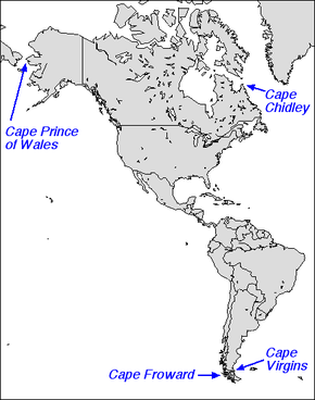
The Cape Prince of Wales on the Seward Peninsula in Alaska is the westernmost point of the American continent with its geographic coordinates .
It is located opposite the Siberian Cape Deschnjow . The Diomedes Islands and the uninhabited Fairway Rock lie between the two capes in the Bering Strait .
The cape got its current name on May 9, 1778 by James Cook , after the Prince of Wales , later George IV. The natives knew it as "M (ys) Nykhta" (Cape Nykhta). On Russian maps, the cape was named "Mys Gwosdewa" (Cape Gwosdew) on Russian maps from 1732 after Michail Gwosdew , a Russian surveyor who landed here in August 1732.
Web links
- Cape Prince of Wales in the Geographic Names Information System of the United States Geological Survey
Individual evidence
- ↑ Lydia T. Black: Russians in Alaska, 1732-1867 . University of Alaska Press, Fairbanks 2004, ISBN 1-889963-04-6 , pp. 26 (English, limited preview in Google Book Search).
