
Kara Bogas Gol
| Kara Bogas Gol | ||
|---|---|---|
| Geographical location | Turkmenistan | |
| Drain | Caspian Sea | |
| Places on the shore | Kara Bogas (Garabogaz) | |
| Data | ||
| Coordinates | 41 ° 21 ′ N , 53 ° 36 ′ E | |
|
||
| surface | 18,400 km² | |
| length | 193 km | |
| width | 154 km | |
| volume | 128.8 km³ | |
| scope | 730 km | |
| Middle deep | 7 m | |

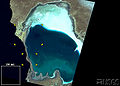
The Kara-Bogas-Gol ( Turkmen : Garabogazköl , Russian Кара-Богаз-Гол ), also Karabugas Gulf , is a shallow, extensive lagoon on the east bank of the Caspian Sea in Turkmenistan . The water has a depth of 4–7 m and, due to strong evaporation , has an extremely high salt content of up to 34%. The water area is around 18,400 km².
The gulf is separated from the north and south by two narrow, sandy headlands , between which a narrow channel runs. The lake water used to flow into the gulf at great speed here. In 1980 a dam was built in this estuary to stop the water level in the Caspian Sea from falling further after decades of lowering. At that time it was not yet known that the water level had been rising again since 1978 and that the measure was therefore superfluous.
After the dam was built, the lagoon dried up completely and turned into a salt desert . This endangers the surrounding environment through deflation (wind removal) of the salt. In addition, the mining of the Glauber salt deposits was no longer possible. Since the installation of locks in 1985–1991 was not enough to improve the situation significantly, the dam was removed again in 1992. The rise of the Caspian Sea ensures that the lagoon fills with seawater again. Since 1996 there has been a countercurrent at the bottom of the canal, so that not only does water flow from the Caspian Sea into the Kara-Bogas-Gol, but also heavy brine from the Kara-Bogas-Gol into the Caspian Sea.
The Kara Bogas Gol is also of economic importance. The lagoon contains the largest deposits of Glauber's salt in the world, as well as table salt , magnesium , boron and potash salts , which are largely processed by the chemical industry .
Due to the high salt content, the lake would be an ideal location for an osmotic power plant, according to researchers from Heidelberg University . Such a device could achieve an output of over 5 gigawatts.
- Development of the water level
1972

1987

1995


_visible_from_a_bridge_on_a_barrier_separating_it_from_the_Caspian_Sea_(left).jpg)
Individual evidence
- ↑ Karabugas in Meyers Großes Konversations-Lexikon, Volume 10. Leipzig 1907, p. 609.
- ↑ Aleksey N. Kosarev, Andrey G. Kostianoy, Igor S. Zonn (2009): Kara-Bogaz-Gol Bay: Physical and Chemical Evolution. Aquatic Geochemistry 2009 (15): p. 234, Springer-Verlag
- ↑ Holger Dambeck : Osmosis power plant: Green electricity from sweet water . March 30, 2012