Karamea River
| Karamea River | ||
|
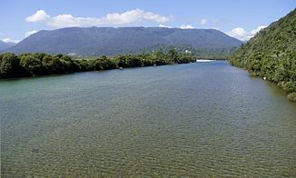
View east from the bridge of State Highway 67 near Karamea |
||
| Data | ||
| location | Tasman and West Coast regions , South Island , New Zealand | |
| River system | Karamea River | |
| source | at the southwest end of Luna Ridge , 7 km southwest of Mount Luna 41 ° 25 ′ 2 ″ S , 172 ° 23 ′ 17 ″ E |
|
| Source height | 1150 m | |
| muzzle | at Karamea in the Tasman Sea Coordinates: 41 ° 15 '47 " S , 172 ° 5' 35" E 41 ° 15 '47 " S , 172 ° 5' 35" E |
|
| Mouth height | 0 m | |
| Height difference | 1150 m | |
| Bottom slope | 14 ‰ | |
| length | 83 km | |
| Catchment area | 1210 km² | |
| Left tributaries | Taipo River , Kakapo River | |
| Right tributaries | Crow River , Leslie River , Roaring Lion River , Beautiful River , Ugly River | |
| Communities | Karamea | |
|
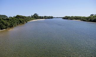
View from the bridge of State Highway 67 near Karamea towards the lake |
||
The Karamea River is a 83 km long river on the west coast of the South Island of New Zealand .
geography
The Karamea River rises on the eastern flank of the 1384 m high Biggs Tops , located at the southwest end of the Luna Ridge . The headwaters are 7 km southwest of the 1630 m high Mount Luna and are part of the catchment area of the Kahurangi National Park . After a right-turning 270 degree arc, the path of the river then leads north, then turns west after the confluence with the Leslie River and swings south in front of the Fenian Range. At the end of the mountain range, the river turns west and flows into the Tasman Sea south of Karamea .
While the lower reaches of the Karamea River belongs to the West Coast region, the greater eastern part of the watercourse belongs to the Tasman region . At the lower part of the river lie the two small settlements Umere and Arapito .
In addition to many streams, the following rivers are among the tributaries of the Karamea River : Taipo River and Kakapo River on the left and Crow River , Leslie River , Roaring Lion River , Beautiful River and Ugly River on the right.
The entire water catchment area of the river covers 1210 km².
use
The river is suitable for trout fishing along its entire course . Studies have shown that in some river sections there are up to 100 fish per kilometer.
Web links
- West Coast region - Surface Water Zone : Karamea . Land Air Water Aotearoa(LAWA),accessed March 2, 2017.
Individual evidence
- ↑ a b c The determination of the coordinates and length of the Karamea River was carried out by Google Earth .
- ^ A b West Coast region - Surface Water Zone : Karamea . Land Air Water Aotearoa (LAWA), accessed March 2, 2017 .
- ↑ a b Topo250 maps - Tasman Mountain - Cape Farewell . Land Information New Zealand , accessed March 2, 2017 .
- ^ Karamea River Trout Fishing . nzfishing.com , accessed March 2, 2017 .

