Karangetang
| Karangetang | ||
|---|---|---|
|
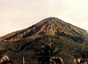
The Karangetang in 1986 |
||
| height | 1784 m | |
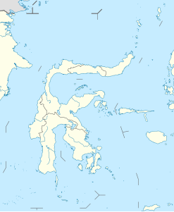
| location | Siau Island , Indonesia | |
| Coordinates | 2 ° 47 '0 " N , 125 ° 24' 0" E | |
|
|
||
| Type | Stratovolcano | |
| Last eruption | 2011 | |
The Karangetang (also: Api Siau ) is a 1784 m high stratovolcano on the northern part of the Indonesian island of Siau near Sulawesi .
The Karangetang has five crater openings in the north-south direction .
Volcanic activity
The Karangetang is one of the most active volcanoes in Indonesia. More than 40 eruptions have been documented since 1675.
- 2006
The highest alert level for the mountain has existed since July 22, 2006. An eruption occurred on July 27, 2006, the second in the month when the volcano threw a gas cloud 2.5 kilometers into the atmosphere and formed a lava flow . Around 3,900 people from six surrounding villages had to leave their localities.
- 2010
On August 6, 2010, the volcano erupted, spewing lava and hot ash hundreds of meters into the air. Four people lost their lives and many others were seriously injured.
- 2011
On March 11, 2011, just a few hours after the severe Tōhoku earthquake in Japan, the eruption broke out again.
Web links
- Karangetang in the Global Volcanism Program of the Smithsonian Institution (English)
- vulkane.net (March 19, 2011)
Individual evidence
- ↑ Eruption history in the Global Volcanism Program of the Smithsonian Institution (English)
- ↑ http://www.nbcnews.com/id/38590966/ns/world_news-asia_pacific/t/feared-dead-after-indonesia-volcano-eruption/
- ↑ thejakartaglobe.com: Mount Karangetang Erupts, Spews Lava and Gas ( Memento of the original from August 29, 2011 in the Internet Archive ) Info: The archive link was automatically inserted and not yet checked. Please check the original and archive link according to the instructions and then remove this notice. (March 11, 2011)

