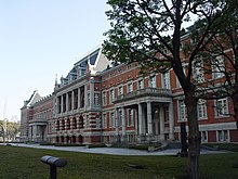
Kasumigaseki
Kasumigaseki ( Japanese 霞 が 関 , also 霞 ヶ 関 ) is a district of the Chiyoda district of the Japanese prefecture of Tokyo . It is located in the center of Tokyo immediately south of the imperial residence and houses numerous ministries and authorities of the central government. “Kasumigaseki” is therefore also used in a figurative sense for the Japanese ministerial bureaucracy; In contrast, Nagatachō - the name of the district that adjoins northwest - designates the elected organs of the government.
The district is limited in the north by the Uchibori-dōri ( 内 堀 通 り ) that runs along the moat of the Imperial Palace , in the east by the Iwaida-dōri ( 祝 田 通 り ), in the west by the Roppongi-dōri ( 六 本 木 通 り ) and the Tokyo city motorway C1 and in the south roughly from the Sotobori-dōri ( 外 堀 通 り ). The Sakurada-dōri ( 桜 田 通 り ) runs centrally from south to north and ends at the Sakurada-mon gate.
The area of Kasumigaseki of 0.48 km² is dominated by office buildings. The district consists of three chôme , in which, according to the 2010 census, a total of four residents lived in four households. The daily population was 59,210 according to the 2005 census. The postal code of Kasumigaseki is 100-0013; however, many buildings or institutions have their own postcodes.
The buildings in Kasumigaseki include:
- the first seven Chūō Gōdō Chōsha (lit. "central, united official building"), in which several ministries and authorities of the central government are housed,
- the Ministry of Foreign Affairs , the Ministry of Finance and the Ministry of Economy, Trade and Industry ,
- the Keishi-chō , the Tokyo Prefecture Police Department,
- the seat of the Tokyo Higher Court , the Tokyo District Court and the Higher Intellectual Property Court ,
- the headquarters of the Japan Post Group , the former state post , and formerly the seat of the Ministry of Post and Telecommunications ,
- the Kasumigaseki Building , completed in 1968 , the first office building in Japan to be over 100 m high,
- the Shin-Kasumigaseki Building with the headquarters of the Higashi-Nihon Kōsokudōro , the East Japanese highway operator and
- the headquarters of Nihon Bengoshi Rengōkai , the Japanese Bar Association.
Four lines of the Tōkyō Metro run through Kasumigaseki, there are the underground stations Sakuradamon and Kasumigaseki. Toranomon Station on the Ginza Line is on the southern border in neighboring Toranomon in Minato District . The inner ring C1 of the Tokyo city motorway, whose operating company Shuto Kōsokudōro KK is also located in the district, runs partially underground on the western edge of Kasumigaseki.
Web links
Individual evidence
- ↑ Chiyoda-ku / Chiyoda City: 町 丁別世 帯 数 お よ び 人口 (国 勢 調査) ( Memento of the original from July 9, 2013 in the Internet Archive ) Info: The archive link was inserted automatically and has not yet been checked. Please check the original and archive link according to the instructions and then remove this notice. (Japanese: "Households and residents by district (census)")
- ↑ Chiyoda-ku: 千代 田 区 行政 基礎 資料 集 (平 成 24 年 版) ( Page no longer available , search in web archives ) Info: The link was automatically marked as defective. Please check the link according to the instructions and then remove this notice. , 1. 人口 ・ 面積 ( page can no longer be accessed , search in web archives ) Info: The link was automatically marked as defective. Please check the link according to the instructions and then remove this notice. (PDF; 869 kB), p. 25: 町 丁目 別 昼夜 間 人口
Coordinates: 35 ° 41 ′ N , 139 ° 45 ′ E

