Katembe (District)
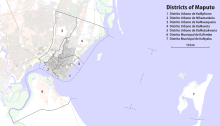
The urban district of KaTembe , in Portuguese Distrito Municipal de KaTembe , or KaTembe , Ka Tembe , Katembe or Catembe for short , is one of seven districts of the Mozambican capital Maputo . Geographically, it covers the entire south bank and is thus spatially separated from the actual area of the capital on the north bank. In 2013 there were 21,569 people in the district.
geography
The district covers the entire area of the capital Maputo , which is located on the south side of the Bay of Maputo or the Estuário do Espirito Santo . While the district is limited to the north and east only by the water of the bay, it is bordered to the south by the Matutuíne district ( Maputo province ) and to the west by the Boane district (also Maputo province) and the Tembe river . The Tembe river is again the namesake of the district, ka tembe means in the local Xitsonga dialect Changana "area at Tembe".
In 2007, the National Bureau of Statistics counted 19,371 people in the district, 20,629 in 2008 and 21,569 in 2013. A slight majority (50.8%) of the district's population lives in concrete houses, the others mostly in huts made of straw or reed (43.3%). The vast majority of the population describes themselves as Christian and belongs either to the Catholic Church (21.3%), the Church of Zion (26.7%) or one of the Evangelical Churches (22.9%).
Administrative division

KaTembe is an urban district ( Distrito Municipal ) of the capital Maputo. In spite of the additional adjective municipal , the district is therefore on an administrative level with the other districts in Mozambique . Below the district level, the National Statistical Office names the following five districts ( bairros ) or localities ( localidades ):
- Incassane ,
- Chamissava ,
- Guachene ,
- Inguide ,
- and Chali .
The Katembe district has only existed since the end of the 1990s, after the capital Maputo was separated from the surrounding province of Maputo as a separate province. In older records there is therefore still an administrative post ( Posto Administrativo ) Catembe, which belonged to the Matutuíne district until the separation .
Economy and Transport
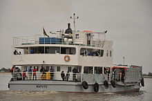
Katembe can be reached from Maputo mainly via the busy ferry traffic between the port of Maputo and the port or the landing stage of Katembe. The state ferry company Transmaritimo has three car ferries and runs in frequent intervals between the two banks. Various smaller boats also transport passengers between the two sides of Maputo Bay. There is also a previously unpaved road that starts directly at the port of Katembe and connects the seaside resort of Ponta do Ouro via Bela Vista (Matutuine district) . At Bela Vista the road also meets the EN202 road to Boane .
The economic center of the district is located directly at the port - the area is colloquially perceived as the "actual" Katembe - where the ferries from Maputo arrive. There are numerous shops and a large market at the port. The majority of the population lives from agriculture and fishing. Another part of the population commutes to the north bank to work in Maputo.
Maputo – Katembe bridge

After numerous and long-term planning, the construction of a bridge over the Bay of Maputo began in 2014 to directly connect the capital city center and Katembe. The construction - financed by the Chinese Exim Bank and built by the Chinese construction company China Road and Bridge Corporation - is scheduled for completion in 2018. In connection with the construction of the bridge, the asphalting of the road to Ponta de Ouro is also planned.
With the completion of the bridge and the expansion of the road to Ponta do Ouro, Katembe is forecast to experience massive population growth to up to 400,000 residents. The entire south bank is also to be urbanized. According to the Betar company's strategic plan for urbanization Katembes, around 9,510,000 square meters (and thus 58.9 percent of the total area) are to be kept free for residential construction. 3,270,000 square meters (20.3 percent of the total area) are earmarked for the service sector, 1,880,000 square meters (11.7 percent) for industry.
Web links
- Statistical profile of the Katembe district , Instituto Nacional de Estatística, November 2013 (PDF, 4.9 MB)
Individual evidence
- ↑ a b c Estatísticas do distrito Katembe. (PDF, 4.9 MB) Instituto Nacional de Estatística, November 2013, accessed on February 7, 2018 (Portuguese).
- ↑ a b c Perfil Estatístico Do Município de Maputo. (PDF, 2.2 MB) CONSELHO MUNICIPAL DE MAPUTO, 2010, accessed on February 6, 2018 (Portuguese).
- ↑ A Nova Katembe - Uma cidade para o futuro. (PDF) Betar, 2014, accessed November 9, 2014 (Portuguese, English).


