Kati
| Kati | ||
|---|---|---|
|
|
||
| Coordinates | 12 ° 45 ′ N , 8 ° 4 ′ W | |
| Basic data | ||
| Country | Mali | |
| Koulikoro | ||
| ISO 3166-2 | ML-2 | |
| Residents | 40,000 | |
|
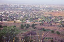
View from the surrounding hills
|
||
Kati is a town in Mali in the Koulikoro region , about 15 km from the capital Bamako . The population is about 40,000.
population
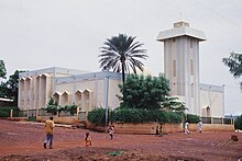
A large part of the approximately 40,000 inhabitants of Kati are of Muslim faith . The language of communication in the region is Bambara , a Mande language , which in many parts of Mali in addition to the official language French is used.
climate
According to the Köppen-Geiger climate classification , the climate in Kati is classified as Aw (tropical savannah climate). In the rainy season from June to September there is heavy rainfall, which averages more than 300 mm in August. From November to April, however, there is hardly any rainfall, during these months less than 40 mm of rainfall is achieved on average. Average temperatures range between 24 ° and 31 ° Celsius, with May being the warmest and January being the coolest.
Town twinning
Kati has several partnerships with other cities:
Web links
Individual evidence
- ↑ Bambara. Retrieved July 30, 2019 .
- ↑ Kati climate: Average Temperature, weather by month, Kati weather averages - Climate-Data.org. Retrieved July 30, 2019 .
- ^ Sister city - Kati (Mali). Erfurt
- ↑ Ville de Puteaux


