
Keppbach
| Keppbach | ||
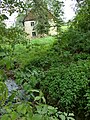
 Keppgrund and south side of the Keppmühle |
||
| Data | ||
| Water code | DE : 5371918 | |
| location | Dresden | |
| River system | Elbe | |
| Drain over | Elbe → North Sea | |
| source | in Cunnersdorf 51 ° 2 '40 " N , 13 ° 52' 40" E |
|
| muzzle | in Dresden - Hosterwitz in the Elbe Coordinates: 51 ° 0 '49 " N , 13 ° 51' 24" E 51 ° 0 '49 " N , 13 ° 51' 24" E
|
|
| length | 5.6 km | |
| Catchment area | 6.1 km² | |
The Keppbach is a tributary of the Elbe in the east of Dresden .
course
It rises in the Schönfeld highlands in the north of the town of Cunnersdorf and flows in a south-westerly direction to the Elbe. The most important tributary is the Schönfelder Bach . When leaving the Schönfeld highlands, the brook deepens into the rock from Eichbusch ( Helfenberg district ) and then flows into the Elbe almost 100 meters deeper through the widening of the Elbe valley after about five kilometers near the church “ Maria am Wasser ” orographically on the right.
natural reserve
The Keppgrund , through which the Keppbach flows, is part of the " Elbe slopes Dresden – Pirna " nature reserve . The flood in August 2002 caused damage of 3.18 million euros in this valley.
Mills
In 1721 there were four mills on the Keppbach. Three of them each had a meal. Today only the Keppmühle is left.
gallery

Pond over the source of the Keppbach
Abandoned Karsch mill on the Keppbach

Keppmühle
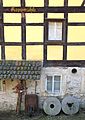
The last two millstones of the Keppmühle
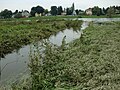
The Keppbach flows into the Elbe


literature
- Sieghart Pietzsch, Local Association Pillnitz e. V. (ed.): Chronicle of Hosterwitz 1406-2006 . Elbhang-Kurier-Verlag, Dresden.
- Gotthold Weicker: The Keppgrund . In: Sächsische Heimatblätter 9 (1963) 1, pp. 69-76
Web links
- Hike along the Keppbach on the trail of the floods (PDF; 2.3 MB)
- Water profile (PDF; 813 kB), accessed July 20, 2010
Individual evidence
- ↑ Anita Urban: Right Dresden mill areas. Dresden-Mühlen.de (PDF; 1.59 MB; no longer available online).