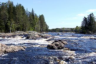
Kiiminkijoki
|
Kiiminkijoki Kiiminginjoki |
||
|
Koitelinkoski in the upper reaches |
||
| Data | ||
| Water code | FI : 60 | |
| location | Kainuu , Northern Ostrobothnia ( Finland ) | |
| River system | Kiiminkijoki | |
| origin | See Kivarinjärvi 64 ° 53 '27 " N , 27 ° 34' 12" O |
|
| Source height | 137.5 m | |
| muzzle | at Haukipudas in the Gulf of Bothnia coordinates: 65 ° 12 ′ 7 ″ N , 25 ° 17 ′ 3 ″ E 65 ° 12 ′ 7 ″ N , 25 ° 17 ′ 3 ″ E |
|
| Mouth height | 0 m | |
| Height difference | 137.5 m | |
| Bottom slope | 0.81 ‰ | |
| length | 170 km | |
| Catchment area | 3,813.6 km² | |
| Drain |
MQ |
43 m³ / s |
| Left tributaries | Vepsanjoki | |
| Right tributaries | Tilanjoki , Kivijoki , Nuorittajoki , Jolosjoki | |
| Small towns | Kiiminki | |
| Communities | Ylikiiminki | |
The river Kiiminkijoki (also Kiiminginjoki ) flows through the northern Finnish landscape of northern Ostrobothnia in an east-west direction . In the upper reaches it leads through a lonely landscape, in the second half the settlement increases. As a typical Scandinavian river, the Kiiminkijoki is a series of lake-like extensions and flowing stretches in between. The largest tributary is the Nuorittajoki . Larger places along the river are Ylikiiminki and Kiiminki .
Web links
Commons : Kiiminkijoki - collection of images, videos and audio files
Individual evidence
- ↑ JÄRVIWIKI - Kivarinjärvi (60.051.1.006)
- ↑ a b Finnish Ministry of the Environment - Kiiminkijoki ( page no longer available , search in web archives ) Info: The link was automatically marked as defective. Please check the link according to the instructions and then remove this notice.
- ↑ Finnish Ministry of the Environment - Suomen päävesistöalueet -taulukko ( Memento of the original from December 4, 2012 in the web archive archive.today ) Info: The archive link has been inserted automatically and has not yet been checked. Please check the original and archive link according to the instructions and then remove this notice.
