
King Fahd Causeway
Coordinates: 26 ° 10 ′ 55 ″ N , 50 ° 20 ′ 41 ″ E
| King Fahd Causeway | ||
|---|---|---|
 |
||
| Crossing of | Persian Gulf | |
| place | between Jasra, Bahrain and al-Chubar , Saudi Arabia | |
| construction | 5 T-beam bridges connected with dams and islands | |
| overall length | 25 km | |
| width | 24.6 m | |
| building-costs | $ 1.2 billion | |
| start of building | 1981 | |
| opening | November 25, 1986 | |
| location | ||
|
||
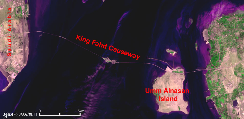
| Satellite image | ||
 |
||

The King Fahd Causeway ( English name in Saudi Arabia and Bahrain , Arabic جسر الملك فهد Jisr al-Malik Fahd , rarely also Bahrain Causeway , German König-Fahd-Damm ) is a combined bridge and dam connection between Saudi Arabia and Bahrain.
The connection was built between 1981 and 1986, with its four lanes is 24.6 meters wide, 25 kilometers long and consists of five bridges connected by dams and islands, which together have a total length of 12.43 km. For the island nation of Bahrain, the dam has been the only road link to the mainland since it opened on November 25, 1986. The increasing economic importance of this connection led to plans for similar projects between Bahrain and Qatar and between Qatar and the United Arab Emirates .
The construction, which was fully financed by Saudi Arabia, cost $ 1.2 billion and required 147,000 tons of steel . In 2001, 2.7 million vehicles with an estimated ten million passengers passed the King Fahd Causeway.
An artificial 66 hectare island was raised halfway, half of which belongs to Bahrain and Saudi Arabia. Bahrain's only land border now runs along it. The island is called Passport Island . In Arabic the name is al-Jazeera al-wasatiyya /الجزيرة الوسطية / al-Ǧazīra al-wasaṭīya in common, in the word meaning central island . On Google Maps , the term shall apply mutatis Middle Iceland ( al-Jazirah al-wusta /الجزيرة الوسطى / al-Ǧazīra al-wusṭā ). Actually, the island was designed in the form of two connected islands , the western one belonging to Saudi Arabia and the eastern one belonging to Bahrain. The structural designation is embankment no.4 . There are seven such embankments along the King Fahd Causeway, of which no.4 is the largest.
See also
Web links
- Satellite image of the causeway
- Saudi Arabian information page on the causeway (en)
- Angular air from Passport Iceland , which clearly shows the double island shows