Kleindingharting
|
Kleindingharting
Municipality Straßlach-Dingharting
Coordinates: 47 ° 58 ′ 10 ″ N , 11 ° 30 ′ 55 ″ E
|
|
|---|---|
| Height : | 671 m above sea level NN |
| Residents : | 93 (1987) |
| Postal code : | 82064 |
| Area code : | 08170 |
|
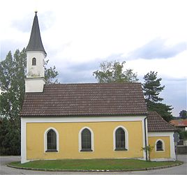
Church of St. Anna
|
|
Kleindingharting is a district of the community of Straßlach-Dingharting in the Upper Bavarian district of Munich .
The church village lies in the open ground in the southwest of the municipality and can be reached via municipal roads from State Road 2072 .
On May 1, 1978, the previously independent communities of Dingharting (with Großdingharting , Kleindingharting and various smaller districts) and Straßlach were merged to form the new community of Straßlach (since 1989 Straßlach-Dingharting ).
In Kleindingharting, the highest point in the area is the Ludwigshöhe (690 m above sea level), which was named after King Ludwig . Shortly before his death, he wanted to build a summer residence on the hill. The avenue for this has already been laid out, and the castle was never built.
Architectural monuments
- Catholic branch church St. Anna
Web links
- Kleindingharting in the local database of the Bayerische Landesbibliothek Online . Bavarian State Library
Individual evidence
- ^ Bavarian State Library Online (BLO). Kleindingharting. In: bayerische-landesbibliothek-online.de. Retrieved December 25, 2019 .
- ^ Federal Statistical Office (ed.): Historical municipality directory for the Federal Republic of Germany. Name, border and key number changes in municipalities, counties and administrative districts from May 27, 1970 to December 31, 1982 . W. Kohlhammer, Stuttgart / Mainz 1983, ISBN 3-17-003263-1 , p. 584 .
