Little Malche


The Kleine Malche is the southernmost bay of the Tegeler See . It is located in the Berlin district of Tegel in the Reinickendorf district .
Location and dates
Its southwestern bank forms a narrow peninsula and isthmus that extends southwest of Saatwinkel between the Berlin-Spandau shipping canal (formerly: Hohenzollern Canal ) and the Tegeler See as far as the Havel . The Kleine Malche, which is closed to shipping, is separated from the Tegeler See by an artificial dam that is not accessible to the public and leaves a 20-meter-wide passage to the lake in the middle. Opposite the bay is the island of Maienwerder , only 40 meters from the dam. The west of the peninsula, towards which Halligweg runs, is occupied by the settlers' cooperative “Auf der Hallig” eG, which is why the entire peninsula is sometimes referred to as the Kleine Hallig . The length of the bay is (from south-east to north-west) 390 meters, the maximum width (from south-west to north-east) 140 meters, with an area of 4.18 hectares or 41,842 m² . The dam to the Tegeler See has a length of 380 meters including the passage. At the east end of the Hallig, the Saatwinkler Steg bridges the Hohenzollern Canal as part of the Berlin – Copenhagen long-distance cycle route .
Former mouth of the Hohenzollern Canal
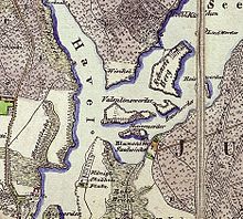
The dam to Tegeler See is not shown on the map from 1842 and did not exist in 1899 either. At this time, the Hohenzollern Canal , which was opened in 1859, flowed into the Kleine Malche on the east bank (as an extension of the Old Berlin-Spandau Shipping Canal , which encloses Gartenfeld , located in Siemensstadt , in a semicircle). With the expansion of the canal in the years 1906–1914 to the Großschiffahrtweg Berlin – Stettin for larger ship dimensions, the canal was pulled west of the Hallig directly to the Havel and thus separated the Hallig from the broke pipes to the south. Its Malche estuary remained in place until at least 1926. The Hallig became an island for some time. In 1938 at the latest, the mouth of the canal in the Kleine Malche was drained. The point in time when the dam to the lake was raised is between 1938 and 1960. The maps from 1926 and 1938 do not show it, but it existed in 1960 at the latest. In contrast, it is already in the Königlich-Prussische Landes-record, allegedly from 1901 (published in 1903 , Edition print 1914) registered; however, the actual year the card was admitted is uncertain.
etymology
The field name Malche or Malchow , which is common in northeastern Germany, comes from the Slavic word for settlement or “place where the people of a man named Malech live.” The addition of “small” was given to the body of water to distinguish it from the Great Malche , the northernmost bay of Lake Tegel.
natural reserve
As the southernmost bay in Lake Tegel, the Kleine Malche is a protected fish spawning area. The bay is part of the LSG-2C Islands landscape protection area in Tegeler See, which was formed in 1960 . Their use is therefore subject to considerable restrictions and in some cases requires special permits from the nature conservation authority, as is the case with bank extensions and the construction of jetties.
Web links
Individual evidence
- ↑ Halligweg. In: Street name lexicon of the Luisenstädtischer Bildungsverein (near Kaupert )
- ↑ Water map, digital map display. Senate Department for Urban Development, FIS broker.
- ↑ Berlin city plan archive, map from 1894 ( memento of the original from December 15, 2015 in the Internet Archive ) Info: The archive link was inserted automatically and has not yet been checked. Please check the original and archive link according to the instructions and then remove this notice. . A map from 1899 shows the same picture.
- ↑ Berlin city plan archive, map from 1926 ( page no longer available , search in web archives ) Info: The link was automatically marked as defective. Please check the link according to the instructions and then remove this notice.
- ↑ Berlin city plan archive, map from 1938 ( page no longer available , search in web archives ) Info: The link was automatically marked as defective. Please check the link according to the instructions and then remove this notice.
- ↑ Berlin city plan archive, map from 1960 ( page no longer available , search in web archives ) Info: The link was automatically marked as defective. Please check the link according to the instructions and then remove this notice.
- ↑ Royal Prussian state admission 1901. Spandau. Published in 1903. Edition 1914. ( Memento of the original from October 11, 2012 in the Internet Archive ) Info: The archive link was inserted automatically and has not yet been checked. Please check the original and archive link according to the instructions and then remove this notice. University of Greifswald
- ↑ Reinhard E. Fischer : The place names of the states of Brandenburg and Berlin . Volume 13 of the Brandenburg Historical Studies on behalf of the Brandenburg Historical Commission. be.bra Wissenschaft, Berlin 2005, ISBN 3-937233-30-X , pp. 111f., ISSN 1860-2436 .
- ^ Reinickendorf cultural history: Saatwinkel .
- ↑ LSG02c Islands in Tegeler See. Senate Department for Urban Development, FIS broker
- ↑ Ordinance on the protection of the landscape of the Tegeler Forest and the islands in the Tegeler See in the Reinickendorf and Spandau districts of Berlin , from October 13, 1960. (PDF; 31 kB) Senate Department for Urban Development
Coordinates: 52 ° 33 ′ 33 ″ N , 13 ° 14 ′ 9 ″ E
